Advertisement
Forecast: Milder Today Before Much-Needed Rainstorms
It’s not as cold this morning as it was Wednesday morning. Lows on Wednesday fell into the teens in some areas, but now readings are on the upswing. The trend for milder weather is going to continue for the next 24 hours before colder weather returns this weekend.
While the main thrust of the big storm which brought a snowstorm to the west have moved into Canada, the tail of the storm, or cold front, is going to eventually to bring much-needed rain.
This morning we find this slow-moving cold front to our west, and it’s far enough away so the rain is also far to the west. This means a dry morning commute with any remaining sunshine fading behind thickening clouds.
There is certainly milder air on the way, but it will take until late afternoon before you feel it. First, across Cape Cod and the Islands, temperatures will rise in the 50s and then eventually make it up to Boston.
Tonight will continue to be mild, and the rain will overspread the region. The image below shows where the rain is expected to be during the evening commute.
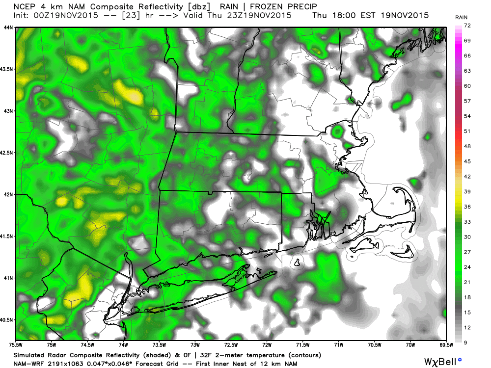
Based on the latest information, the bulk of the steady and heaviest rain will remain west of metro Boston until after most of you are home.
I expect half of an inch to an inch and half of rainfall, with the heaviest amount of rain west of Route 495 and the least amount falling on Cape Cod.
The rain will end early on Friday during the morning commute. There’s a chance the rain will be over by the start of the morning commute Friday, and that most Bostonians avoid weather issues for both drives.
The weekend looks chilly and other than a brief shower (or snow flurry over higher terrain near New Hampshire) Sunday, it will be dry. Presently, much of Thanksgiving week will also be dry and seasonable with a slow warming trend.
Today: Thickening clouds, chilly early, then milder by days end. A few showers late in the day. Temperatures in the 50s by 5 p.m.
Tonight: Breezy and mild, showers and perhaps a heavy downpour. Temperatures in the lower 50s.
Friday: Mild in the morning with a few showers. Temperatures near 60 early, then 50 by dark.
Saturday: Mostly sunny, with a high in the upper 40s.
Sunday: Lots of sunshine. A quick shower. High in the upper 40s.
Monday: Mostly sunny and cold. Highs 40-45.
Tuesday: Mostly sunny, with a high in the mid 40s.
You can follow David’s weather updates on Twitter at @growingwisdom.
