We've updated snowfall totals based on some heavy bands that were moving through the area at 3 p.m.:
Upped totals 2-5" based on current heavy bands. There won't be a water shortage to start spring. pic.twitter.com/iFb5bN9ofV— Dave Epstein (@growingwisdom) February 2, 2015
Our original post continues:
A winter storm Monday will drop on average to between 6 and 12 inches with a bit more likely just west of Boston and less snow over the South Shore, Cape Cod and the Islands.
If you can avoid travel I highly recommend it as snowfall rates will average 1 to 2 inches per hour through about noon and could go a bit higher in pockets. This intensity of snow makes it difficult for the road crews to keep up.
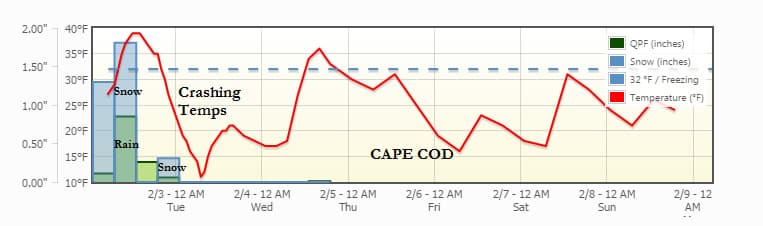
There is warmer air associated with the storm. This will bring the mix-rain line slowly north. I expect the line to make it about as far north as a line from about Boston to Hartford about 1 p.m. Where there is rain occurring later this morning and early afternoon, the snow is going to become wet and heavy. Temperatures over much of Cape Cod will exceed 32 and some of the snow will melt.
Snow remains heavy early this afternoon before tapering to periods of snow, at times moderate for the evening commute. Areas with rain and mixed precipitation will change back to snow before the entire storm ends between 9 and 11 p.m.
Later this evening the temperature will rapidly fall and these same areas that reached over 32 earlier will be at 12 by Tuesday morning. This means I highly recommend clearing all the snow and slush before 8 p.m.
Boston won’t change to rain, but there too it will become milder and then very cold this evening. Use the mild period this afternoon to shovel because it will be very cold Tuesday.
Winds will be very gusty late in the storm, especially across the North Shore where the wind and snow can combine to continue travel issues and create some big drifts.
Tuesday is calm and cold. I see a few flurries or snow showers possible mid-week, but no storms into the weekend.
Forecast for Cape Cod. (Click to enlarge)
Monday: Snow, heavy at times this morning. A mix or change to sleet and rain south of the Massachusetts Turnpike toward Cape Cod. A return to snow later in the afternoon. Highs of 22 to 37.
Monday night: Snow early, then clearing and blustery. Lows of 2 to 13.
Tuesday: Mostly sunny with a high near 20.
Wednesday: A few snow showers and milder. Highs around freezing.
Thursday: Lots of clouds and some sun. Highs in the mid 20s. A passing snow shower.
Friday: Mostly sunny. Cold with highs of 15 to 20.
You can follow David’s weather updates on Twitter at @growingwisdom.
This article was originally published on February 02, 2015.