Advertisement
Forecast: Warm — Though Unlikely Record-Breaking — Temperatures For Next Two Days
A frontal system this morning brought a few showers to mostly eastern areas of the region with up to half an inch of rainfall.
This front represents the dividing line between mild air and downright warm air to our south. During the morning and early afternoon this front should push northward and allow the very warm air into most of the region.
If — and it’s only an if — the front takes longer than forecast to move northward, the warmth won’t make it to points north and east of the Route 128 belt, meaning the air will end up cooler than forecast. Boston could stay in the 60s until well into the afternoon.
The front will likely take long enough to traverse Boston that temperatures will not make it to the record of 82 degrees and instead may reach the 70s at Logan Airport after 3 p.m. The earlier the front moves through, the further into the 70s your area will be, with the best shot at seeing 80 degrees occurring southwest of the city.
Tonight the region remains in the mild air. Many areas will stay in the lower 60s all night. And while some of the coolest readings will be in the upper 50s, this is more typical for highs than lows in mid-October.
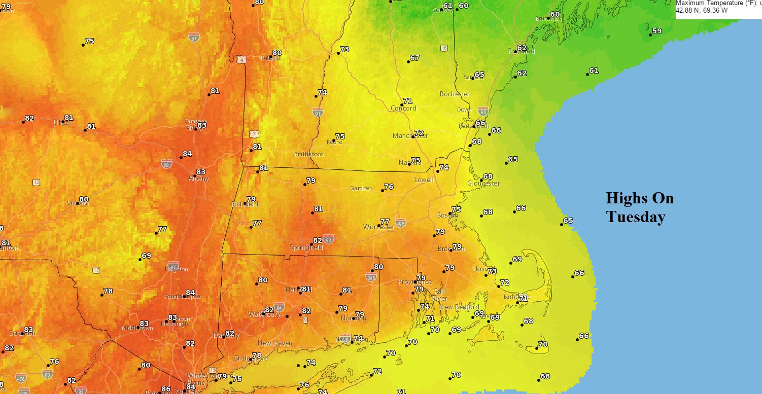
Another warm day is coming up tomorrow with regional readings in the 70s. Areas along the south coast stay in the lower 70s while inland areas reach the upper 70s to as near as 80.
Thursday and Friday are looking unsettled with periods of showers or even a steady rainfall. This is great news for the drought. I'll have more details on how much rain we can expect tomorrow.
You can follow my weather updates on Twitter at @growingwisdom.
Tuesday: Dense clouds give way to a blend of clouds and sunshine. Highs 68-72 for northeastern areas and 71-80 from Boston southwest, with coolest temperatures at the Cape and the Islands. Temperatures will stay in the 60s for much of the day in Boston before the warmth surges north.
Tuesday night: Partly cloudy with some fog. Lows 58-64.
Wednesday: Partly sunny and warm. Highs 75-81, cooler south-facing coastal areas.
Thursday: Clouds thicken, showers develop. Highs in the lower 60s.
Friday: Cloudy with a period of rain. Highs in the mid to upper 60s.
Saturday: Mostly sunny and seasonable. Highs in the mid 60s.
Sunday: Mainly sunny and cooler. Highs in the upper 50s.
