Advertisement
Forecast: Record Heat Thursday
Boston reached 92 degrees Wednesday — not quite a record, but nevertheless significantly above average for the time of year.
Thursday will mark another 90-degree day, the 23rd of the summer. This will put this summer in sixth place for the most 90-degree days — just one week behind 1983, which had a whopping 30.
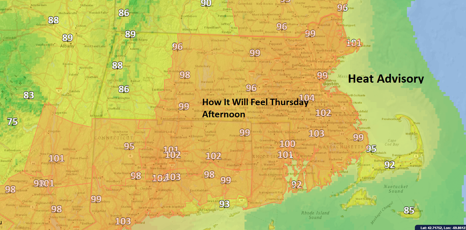
Temperatures this afternoon will feel near 100, especially with those high dew points. There is going to be a major change in the weather late in the evening and particularly this weekend. Drier and cooler air will finally move into the area then. It's going to actually feel more like fall and will give us a chance to breathe a little bit and turn off the air conditioning.
As this frontal system approaches, there is the risk for showers and thunderstorms. If you want to head to the beach today, the best time will be before 2 p.m. After that, the clouds will build and the chance for storms increases.

The greatest risk for severe weather will be south of the Mass. Pike, especially as you get over interior southeastern Massachusetts. But there's still the chance for thunderstorms in much of southern New England. The widely scattered nature of these storms means you might not see anything.
The problem this weekend is the front will be quite close by weather standards. I am concerned clouds will dominate the skies, especially south of the Pike.
Temperatures this weekend will be in the upper 60s and lower 70s. The dew points will be quite low, meaning temperatures in the morning will be in the 50s. This will be one of the coolest weekends in Boston we've seen since June.
Finally, Hurricane Florence will continue to move west over the next week. It definitely bears watching and could affect the U.S. by the middle of next week.
You can follow my updates here and on Twitter @growingwisdom.
Thursday: Sunshine and clouds, highs 88-95. There will be a chance of showers and storms later in the day. Some could be strong.
Thursday Night: Any showers/storms end, some clearing. Cooler. Lows 62-67.
Friday: Clouds, some breaks north. Thickest clouds south. Much less hot. Highs 75-80.
Saturday: Cloud to party sunny and clouds. Quite pleasant. Highs 70-75.
Sunday: Clouds to partly sunny. Cool. Highs in the upper 60s to lower 70s.
Monday: Clouds, some sun. Wide range in temperatures possible as readings go from the 70s to 80s north to south.
