Support WBUR
Patrick Declares Emergency Ahead Of Earl
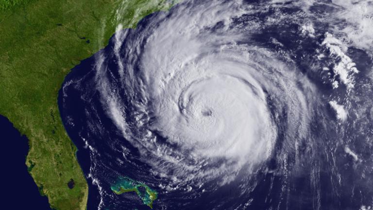
Hurricane Earl, the strongest storm to threaten New England in 19 years, raced toward regional waters Friday as officials prepared to close beaches, open emergency shelters and inspect drainage systems.
"This is the strongest hurricane to threaten the Northeast and New England since Hurricane Bob in 1991," said Dennis Feltgen, a meteorologist with the National Hurricane Center.
Massachusetts Gov. Deval Patrick declared a state of emergency ahead of the storm's arrival, saying the declaration would allow officials to respond quickly. He also urged people living in low-lying areas prone to flooding to consider leaving their homes by Friday afternoon.
"We're asking everyone: Don't panic," Patrick said. "We have prepared well, we are coordinated well, and I'm confident that we've done everything that we can."
Ferries between Cape Cod and Nantucket were expected to stop running before noon and the island had already seen a steady exodus of boats Thursday. Those that remained were being "spider moored," meaning they were all tied together. Windows at town-owned buildings were being boarded and the island pulled lifeguards from public beaches at noon Thursday.
"We're recommending people not go in the water," said Gregg Tivnan, Nantucket's assistant town manager. "In fact, we're encouraging people not to even go on the beaches on the southern parts of the island. One wave is all it takes to sweep someone away."
Rhode Island Gov. Donald Carcieri signed a declaration of disaster emergency on Thursday, giving emergency workers access to state and federal resources to deal with problems that may be caused by the hurricane. The move authorizes emergency responders to activate a search-and-rescue team and gives officials the power to order the evacuation or closure of areas hit or threatened by the hurricane, including beaches and campgrounds.
In Connecticut, Gov. M. Jodi Rell pressed President Barack Obama to declare a state of emergency for her state.
"I have determined that this event is of such severity and magnitude that effective response is beyond the capabilities of the state and affected local governments as well as voluntary organizations," Rell said in a letter to Obama. "Because of the regional nature of this event, regional resources are anticipated to be stretched thin."
The projected path of Hurricane Earl shifted closer to the island of Nantucket as the storm's winds slowed from 140 mph early Thursday to 105 mph, Category 2 strength, by early Friday.
The National Hurricane Center issued a hurricane warning for the Massachusetts coast from Westport to Hull, including Cape Cod and the Islands, with Nantucket expected to be the hardest hit.
A tropical storm warning was in effect from New Haven, Conn., to Westport, Mass., including Block Island, R.I., from Hull to the Merrimack River, and from Stonington, Maine, to Eastport, Maine.
A tropical storm watch was in effect from the Merrimack River to Stonington.
Earl was expected to reach New England waters Friday night. The National Weather Service predicted winds gusts up to 85 mph for Cape Cod, and gusts of more than 100 mph on Nantucket. Meteorologist Charlie Foley said there's not expected to be any significant storm surge.
"The main impact would be high surf, dangerous rips, heavy rain and wind," he said.
At Arno's Main Street Grill on Nantucket, owner Chris Morris said he hoped to keep the restaurant open as long as possible. The storm may even be good for business, he said.
"There's not much else to do during a hurricane besides eat and drink," Morris said. "I mean, there's only so many times you can visit the whaling museum."
To the south, another tourist destination, Block Island in Rhode Island, was expected to see hurricane-force gusts, state officials said. J. David Smith, head of the state Emergency Management Agency, said the last ferry was leaving the island Thursday for the hour-long ride back to the mainland.
Carcieri said he expected the rest of the state to miss the worst of the storm. Still, the governor advised people to secure their houses, pack their cars and fill their gas tanks in case the storm track changed.
In New Hampshire, the storm appeared to be headed east of the state but officials were encouraging homeowners who live near the coast to have extra batteries and water. Officials in Rye said they would close all the town's beaches because of possible dangerous ocean currents.
Hundreds were leaving their island summer homes in Maine before the traditional end of the season on Labor Day because of the threat of a weekend washout, said Philip Conkling, president of the Island Institute. Most who live on the state's 15 islands with year-round populations will likely ride out the storm, assuming it doesn't change course, he added.
"Everyone is really riveted to the storm track information because this could be 50 knots of wind and a lot of rain, or, with a slight change in the track, it can be 100 knots of wind. That's just a huge difference," Conkling said.
Clayton Smith and his colleagues at Rockport, Maine,-based Yachting Solutions were scrambling to get boats to safety, though they were unsure about the hurricane's path. He said his company planned to pull 40 boats from the water in 48 hours.
"Complacency is a bad thing," he said. "It's better to be safe than sorry."
Related Stories:
This program aired on September 2, 2010. The audio for this program is not available.