Advertisement
Forecast: Snow Showers Today, Bracing For A Frigid Weekend
Today gives us another day with some snow showers, but there won't be a lot of them — and certainly no big accumulation. Like yesterday, some areas could see roads whiten for a time, especially the ones less traveled.
Temperatures will be far chillier than yesterday so roads may be more slippery. While the sun is getting stronger this time of year, it’s still relatively weak.
Temperatures will fall fast overnight as skies clear, and by Friday morning we will be in the single digits. It will be the coldest morning of February so far, as well as the coldest since the middle of last month.
While this air is quite chilly Friday, it’s not the super cold air arriving Saturday through Monday morning. That will come behind another frontal system tomorrow.
The trajectory of air is straight across the North Pole and into New England for about 48 hours this weekend. Boston could very well fall below zero this weekend something that doesn’t happen much anymore.
Back in 2004, Boston’s Logan Airport reached 4 below zero and it hasn’t been that cold since. Last winter we reached -3. This weekend Logan will hit 2 or 3 below, but I don’t think the 4 below zero mark. You might be surprised Boston’s only fallen below zero 9 times in the past 21 years.
The high temperature on Sunday will be near record cold territory. Most of the day temperatures will remain under 10 degrees, but it might reach 11 degrees for the official high temperature.
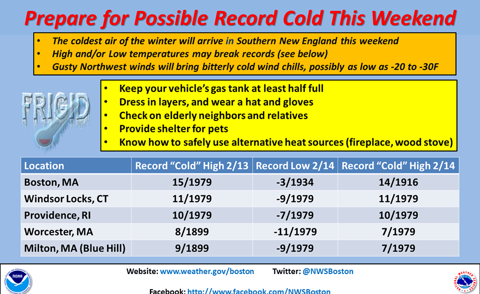
The image below shows some of the records for the weekend.
Temperatures will moderate Monday afternoon and by Tuesday there will be some rain or snow with temperatures rising above freezing.
You can follow my weather updates on Twitter at @growingwisdom.
Today: Lots of clouds, a snow shower or squall. A coating to an inch in isolated areas. Highs 27-34.
Tonight: Turning colder with clearing skies. Lows 5-15.
Friday: Mostly sunny, with a high near 25.
Saturday: Cold and dry, with highs in the teens, but temperatures falling late in the day.
Sunday: Bitter cold. Temperatures under 10 most of the day. Lows near or below zero.
Monday: Mostly sunny with a passing snow shower. Not as cold. Highs 23-27.
