Advertisement
Forecast: One More Warm Day — But With Risk Of Showers All Day
If you read yesterday's forecast you know I was thinking Boston and surrounding areas could reach 70 degrees if there was enough sunshine. Well, the temperature did reach 70 at Logan Airport — and many other areas — for what is likely to be the last 70-degree day for a while. This is typical for New England. Climatologically, the final 70-degree afternoon occurs the first week of November.
Today the weather map features a frontal boundary slicing through New England. North of this boundary, it will be quite cool with readings in the 40s and 50s this afternoon. There will also be a period of showers.
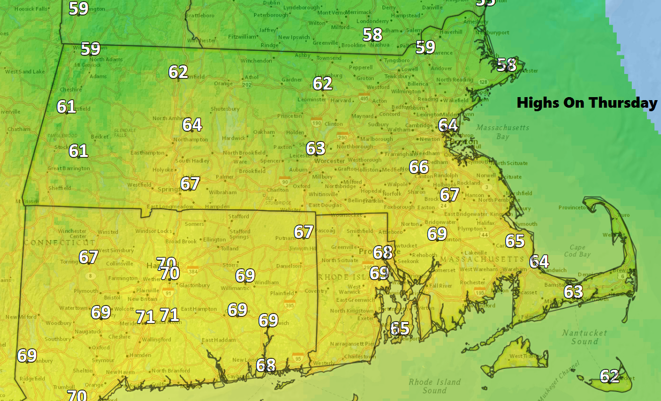
To the south of the boundary, one more warmish day is coming with readings well into the 60s. This dividing line will run through southern New England, giving Massachusetts a wide range of temperatures. The north shore likely stays in the 50s today with the southwest suburbs south of the Turnpike back in the 60s. I can't rule out another 70-degree reading over parts of Connecticut, but not in Boston.
The risk of showers is present all day. The heaviest will be across central and northern Massachusetts with less rain over Cape Cod. Generally, we are looking at a tenth to a half an inch of rain, nothing major by any means. The timing of the rain keeps it out of Boston until just before or during the commute. Since amounts are forecast to be light, I don't expect big issues for the ride home, but wet roads do slow things down.
Clearing skies arrive Friday with much cooler and drier air. It will feel like fall again, and this pattern holds through the weekend.
You can follow David's weather updates on Twitter at @growingwisdom.
Thursday: Showers and perhaps a heavier downpour. Times of dry weather as well, but cloudy. Temperatures reach the 60s south of the Mass. Pike, but 50s to the north.
Thursday Night: Showers end, cooler by morning. Lows in the lower 40s.
Friday: Becoming sunny and cooler. Highs 50-55.
Saturday: Lots of sunshine. Highs in the lower 50s
Sunday: Partly sunny and cool. Highs around 50.
Monday: Mostly sunny and seasonable. Highs around 50.
Tuesday: More sunshine. Highs in the low to mid 50s.
