Advertisement
Forecast: Heavy Snow Coming Thursday
Today's weather was messy and tomorrow's weather is springlike, but Thursday is the day you'll want to pay attention most closely to the forecast.
A warm front lifting northward today brought a period of snow, sleet and rain to the region. As this front lifts northward, rising temperatures will continue through overnight. This sets up several hours of springlike temperatures for tomorrow, when highs reach the lower 50s! It's been near 70 in the Washington, D.C., area this afternoon and that warm air is part of the reason a storm is going to form.
Unless you've only been in New England a short time, you know 50s one day and a snowstorm the next isn't really that unusual. The chances of a major snowstorm have been in the cards for a few days and now the models are coming into better agreement on this situation.
A few things about the storm: It won't be a crippling snowstorm where you can't get out for two days. It's a fast moving storm and will bring all of its snow rather fast. This means Thursday itself is going to be a difficult day of travel.
Logan Airport will likely see numerous delays and cancellations for Thursday and into early Friday. If you have plans to travel Thursday, plan on disruptions.
I expect the snow to develop early Thursday and end in the first part of the evening. The storm is two days away and timing will change. It might move up or be delayed a few hours from my current thinking.
In terms of accumulation, I think 8 inches of snow is a good bet in Boston, but this could go over a foot. I've made the range fairly large right now and will refine tomorrow after more data comes in. It may be a 6-9-inch storm or a 12-14-inch storm when it's all over, but presently I am leaning toward larger, not smaller.
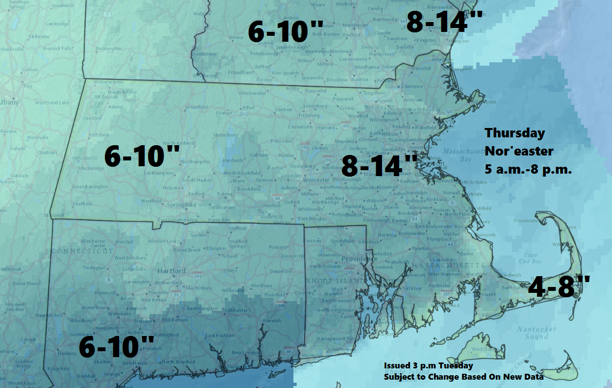
The storm may start as rain across Cape Cod and the Islands as the warm air will still be in place. However, as colder air moves south, the snow will start there as well and I expect a plowable storm.
You can follow my weather updates on Twitter at @growingwisdom
Tonight: Periods of rain before 8 p.m. Raw and chilly. Lows in the mid 30s, then rising to 40 degrees by morning.
Wednesday: Early showers, then clouds with a few breaks of sunshine. Highs 53-59.
Thursday: Heavy snow developing early. Rain changing to snow over Cape Cod. Temperatures falling to the 20s.
Friday: Sunshine and clouds. Highs in the mid-20s.
Saturday: Mostly cloudy. A few snow showers possible. Highs 35-40.
