Advertisement
Forecast: 'A Bit Freaky': Another Day With Temps In The 60s
Yesterday Boston and many areas saw temperatures in the mid- and upper 60s. A few spots even managed a 70-degree reading.
For Bostonians, it was the second warmest February day on record and the warmest Feb. 23 since records began in the late 1800s. Burlington, Vermont, Toronto, Canada and Albany, New York were just some of the places seeing their warmest February day ever recorded.
To the southwest, McAllen, Texas reached 100 degrees, the earliest such occurrence on their record books. We might all enjoy a warm weather break in the winter, but this kind of warmth isn't necessarily a good thing and is a bit freaky.
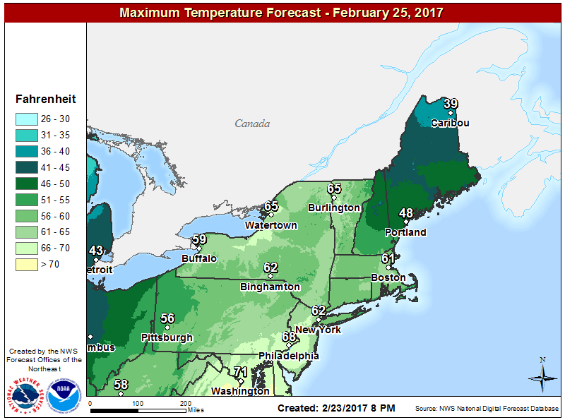
Again today we have more warm air in place. Like yesterday, temperatures along the coastline south of Boston will be much cooler. Readings in the upper 40s and lower 50s will be common on the south side of Cape Cod and the Islands.
The rest of us will see readings reach and exceed 60 degrees. If there's enough sunshine, highs in the upper 60s are possible again. Today's record in Boston is 70 degrees, which is the warmest February reading in the books, but we won't reach it.
On Saturday, the warmth continues. However, its end is in sight.
A cold front will be marching east and pushing the exceedingly warm air ahead of it. Behind this front temperatures are still above average, but only by about 5 degrees, instead of 25 or 30. The transition to the cooler air will be marked by showers and even a period of rain. There could be a few thunderstorms embedded within.
On Sunday, sunshine returns, but it will be colder. Temperatures in the 40s are going to feel much chillier than they typically would at the end of February. The chill doesn't last long though. There is the potential for more 60-degree weather in the middle of next week. Winter might not be over, but it's certainly taking a beating.
You can follow my updates on Twitter at @growingwisdom.
Friday: Lots of clouds some sunny periods, may shower. Highs around 50-55 Cape Cod; 60-68 elsewhere.
Friday Night: Mainly cloudy and mild. Lows in the 40s.
Saturday: A few showers by the end of the day. Maybe nighttime thunder. Mild with highs in the upper 50s and lower 60s.
Sunday: Becoming mostly sunny and cooler. Highs 41-45.
Monday: Mostly sunny and seasonable. Highs in the mid-40s.
Tuesday: Partly sunny, may shower. Highs near 50.
