Advertisement
Today's Weather: A Beautiful Day — Then A Major Rain Event Tomorrow
We have a beautiful day on tap, with plenty of sunshine and temperatures getting well into the 40s. This will be a wonderful opportunity to continue to do your shopping as well as any outdoor activities. I recommend checking gutters and sump pumps today with a pretty big rainstorm for tomorrow and early Saturday.
A storm system across the Southeast will move up the Appalachian chain and through New England Friday night and Saturday.
Storms generally have two sides to them: a cold side and a warm side. If a storm passes to our west we end up on the warm side with a strong southerly flow of air. This will be the case Friday night and Saturday. As that southerly flow picks up, winds will be quite gusty and it's not going to surprise me if we see some scattered power outages. The ground is pretty saturated and although there aren't any leaves on the trees, the wind should be strong enough to do a little bit of tree damage. The strongest winds will be from midday Friday on through the evening.
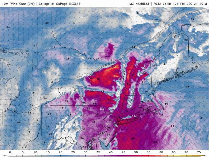
There could also be some thunderstorm activity as well. There’s even an outside chance of a bit of severe weather, mainly over southeastern Massachusetts.
In addition to the wind, rain will be heavy at times Friday and Friday night. It looks to me like there's going to be significant rain before sundown and then a lighter, second batch of rain comes in Friday night. The timing of this break is important because many will be exiting the area for the long holiday weekend.
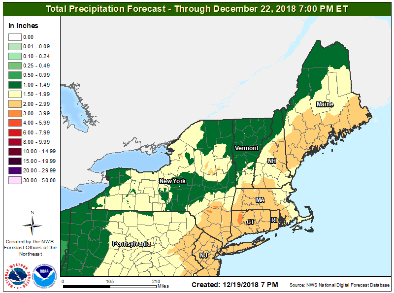
Rainfall will be on the order of 1.5 to 2 inches. This is enough to have prompted the National Weather Service to issue flood watches tomorrow into Saturday. Rivers and small streams could near flood stage and there will inevitably be street flooding.
Everything winds down early Saturday with rain ending and mild temperatures. It remains cold and dry after that into Christmas.
You can follow my updates here and on Twitter @growingwisdom.
Thursday: Sunshine and not as chilly. Highs in the mid 40s.
Thursday Night: Clouding up, rain by morning. Lows 35-43.
Friday: Mild with showers, some periods of heavy rain and possible thunder. Very breezy. Highs in the 50s to lower 60s.
Saturday: Leftover showers possible, otherwise cloudy. Highs around 50.
Sunday: Mainly sunny and highs near 43.
Christmas Eve: Dry and chilly. Highs 38-42.
Christmas Day: Cold and bright. Highs 33-38.
