Advertisement
Forecast: Colder Air Today, Some Light Snow Friday And A Bigger Storm Sunday
ResumeTHURSDAY AFTERNOON UPDATE -- As the approach of the weekend's big snowstorm gets closer, there are no real significant changes from this morning's update. There will be a burst of heavy snow early Sunday, but that will change to a mixture of snow/rain, keeping snowfall totals from becoming too high throughout Greater Boston.
However, there will be over a foot of snow that falls across northern New England and some areas of southern New England.
A cold front went through the area last night and has ushered in some modified Arctic air which will be with us for the next couple of days. You'll notice temperatures today will be about 10 degrees cooler than yesterday. Additionally, there's a bit of a breeze, making it feel even chillier.
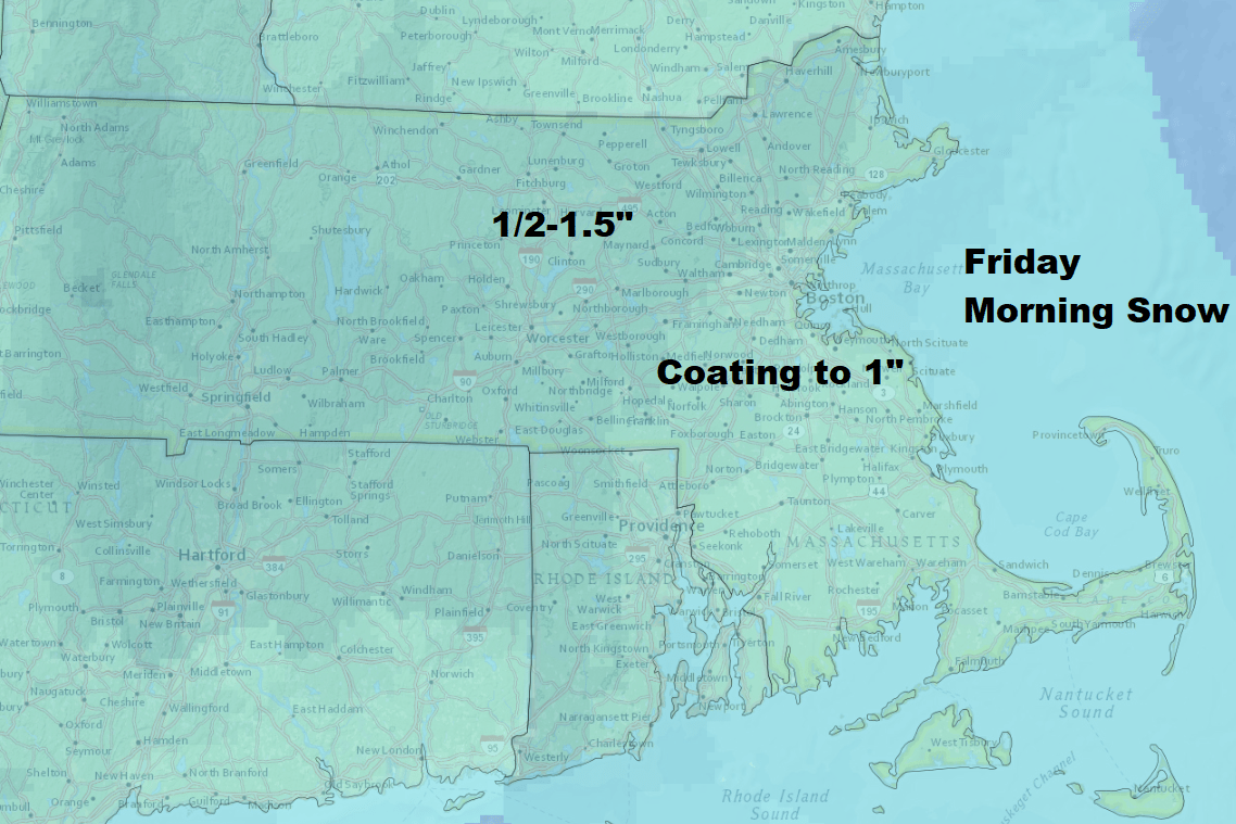
A small low pressure area will pass east and south of New England early Friday bringing a few hours of light snow. This snow will change to rain before ending especially south of Boston. My accumulation map has not changed since yesterday and I'm still thinking up to 1.5 inches in a few spots in central and western areas but less around Boston.
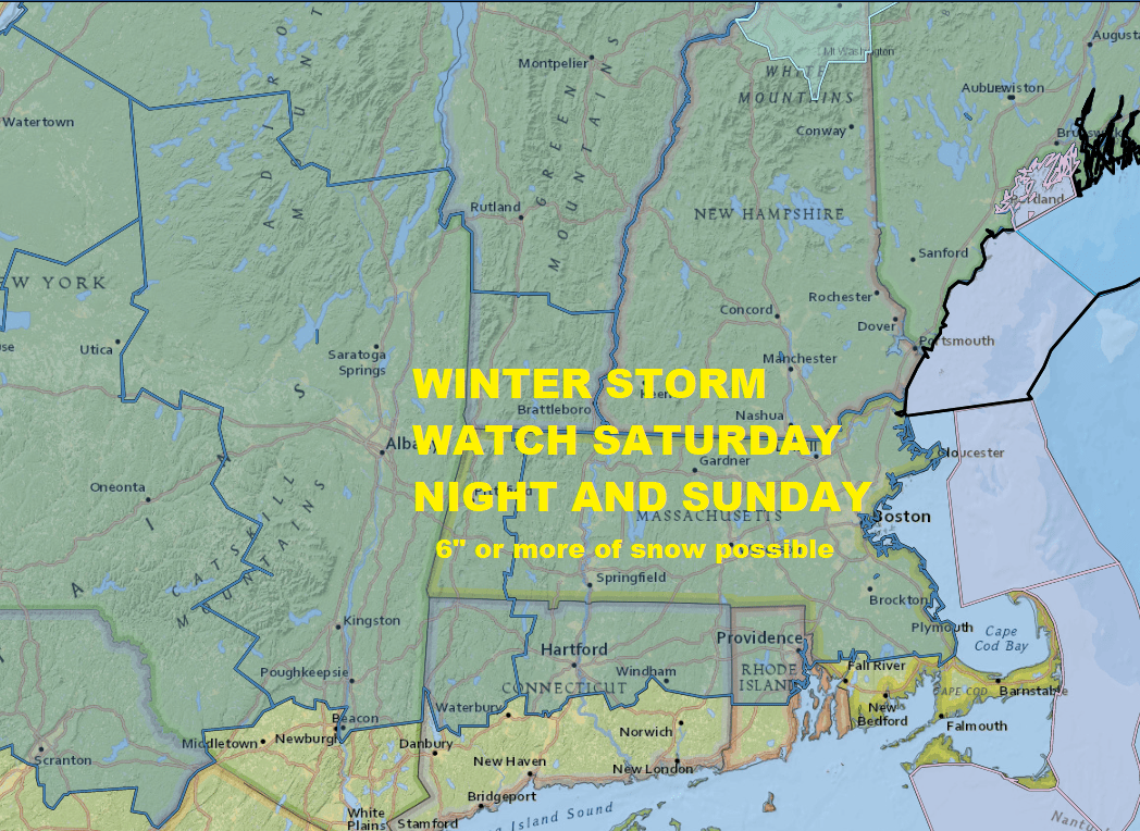
There will be a lull in the action on Saturday before our more important storm arrives Saturday night and Sunday. I've written this several times over the past few weeks — don't let the level of hype dictate your level of anxiety. This is just a storm and we've had many of them before and we'll get lots of them afterwards.

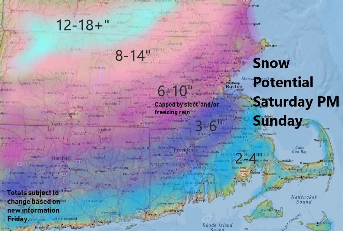
This is one of those storms where there will be a very wide range in temperature and precipitation types across New England. There's no doubt that the front part of the storm those first few hours after the precipitation begins will be in the form of snow. There's also little doubt that the ending of the storm will be in the form of snow. Boston will likely see most of the snow accumulation Saturday evening into early Sunday before a change to sleet or other mixed precipitation.
What's going to happen in those critical hours during the middle of the storm is still in question, especially from Boston south and east. Depending on where you are, it will mean the difference between several hours of mixed precipitation, several hours of rain or a total snow storm.
This obviously has tremendous impact on how much snow you measure when the whole thing's over. I’ll have a better idea tomorrow and be able to put more specific numbers for specific areas, but even then you should expect changes.
If this stays all snow I would think somewhere either side of a foot would be expected. This would most likely occur in western, southern New England and up north. If the storm is all snow, Boston is in the 12 inch range as well. Half the snow falls by 8 a.m, Sunday, 4-8 inches of snow for the Boston area, more north and west.
Sunday During The Day
How far north the mix line moves Sunday is key to the forecast. There's more snow during the day Sunday and depending on how cold it is will determine if its more sleet than snow. We could add another 4-8 inches on top of what falls Saturday night. Plan on less as you head to Cape Cod and more inland towards New Hampshire border.
Coastal flooding will be an issue, but not a major one. Light to moderate coastal flooding typical of winter storms should be expected for those of you at the coastline.
Another definite from the storm is going to be the Arctic air that comes in behind it. If you end up with a lot of slush it's going to freeze rock solid. If you end up with a lot of ice, it's going to just become even harder. The word flash freeze gets thrown around a lot and often it doesn't happen, but in this particular case, temperatures are going to plummet very quickly and any standing water will freeze Sunday night. It's going to be important that you try to clean up relatively quickly as the storms happening so that you don't end up with a driveway full of bricks.
Ski country will do very well with snowfall from this storm and if you can tolerate the bitter cold on Monday it will be simply amazing conditions.
You can follow my updates here and on Twitter @growingwisdom.
Thursday: High clouds and sunshine. Colder. Highs in the mid-20s to approaching 30.
Thursday Night: Clear to partly cloudy and chilly. Lows 15-20.
Friday: Morning snow with light accumulation. May change to rain before ending. Highs 35-40.
Saturday: Chilly and dry, snow at night likely, heavy by midnight. Highs in the 20s.
Sunday: A mixed bag of precipitation likely with a wide range of temperatures. Hard freeze at night.
Monday: Blustery and very cold. Highs 10-17.
This article was originally published on January 17, 2019.
This segment aired on January 17, 2019.
