Advertisement
Today's Weather: A Bit Of Snow And Briefly Bitter Cold
You've probably heard about the cold that's enveloping the middle part of the country — and a bit of that will arrive in New England tomorrow night into the early part of Friday. While it will be cold and Thursday's high could be the coldest we've ever seen for the final day in January, I'm not expecting the cold to last and now-record lows to be broken.
On Tuesday, we find low pressure heading up into New England, producing a bit of an onshore flow. Many areas in eastern Massachusetts will see some snow in the air throughout the day and these situations can create a few icy spots as well as coat the ground.
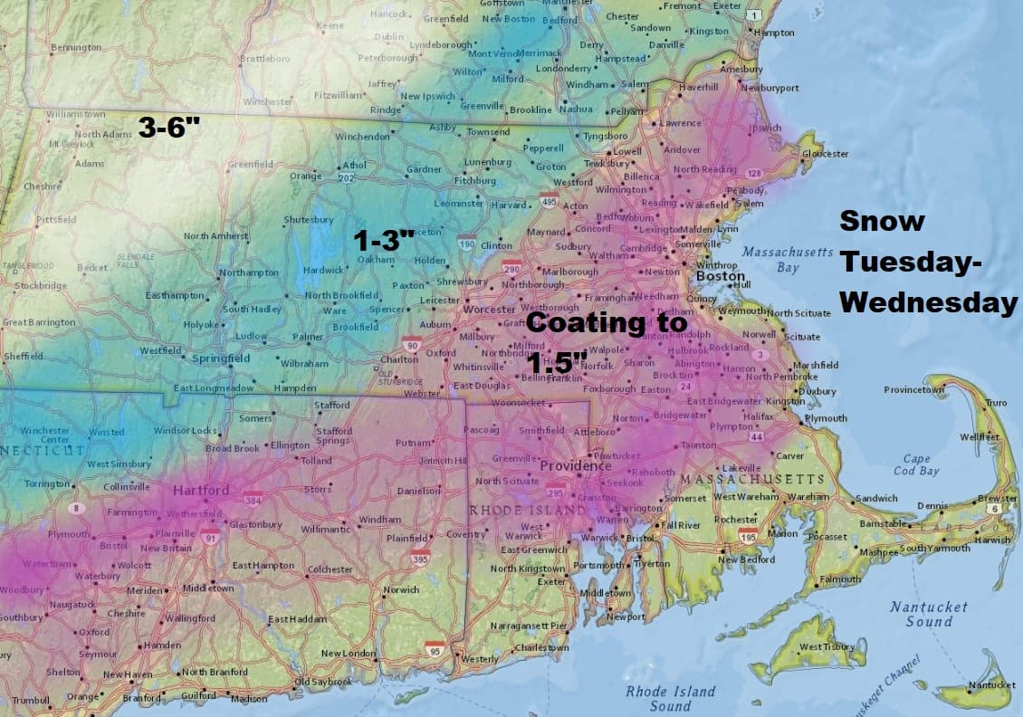
Later in the day, a more organized area of snow mixed with some rain will push through the region and this could bring up to an inch and a half of snow over eastern areas, with one to three inches further west and a little more across the Berkshires. The highest totals are expected to fall in Maine. Ski areas should actually do quite well out of the system with four to eight inches of snow in that area.
This means that there may be some slippery spots for the evening commute on Tuesday and then again Wednesday morning. On Wednesday, we will start to see some clearing skies before the Arctic front, the leading edge of that bitter cold air, moves into the region. These can be accompanied by snow squalls — brief bursts of heavy snow which can create very icy conditions in a short period of time. That would happen during the evening commute on Wednesday.
The bottom line is that over the next 36 hours, plan on changing road conditions. Dry weather continues for Thursday and Friday.
You can follow my updates here and on Twitter @growingwisdom.
Tuesday: Cloudy, some coastal light snow likely. Highs in the mid-30s. Little accumulation.
Tuesday night: Snow and rain and snow over southeastern Mass.
Wednesday: Some morning snow, then clearing and blustery. A snow squall late in the afternoon/evening. Highs 32-37.
Thursday: Very cold and sunny. Highs 5-15.
Friday: Sun and clouds. Highs in the mid-20s.
Saturday: Sunny and cold. Highs in the mid to upper 20s.
