Advertisement
Forecast: Tropical Storm Watch Issued For Cape Cod
A cold front passed through the area Wednesday, and many of us actually missed the shower activity associated with it. Today, we find lots of sunshine and seasonably cool weather with very dry air in place. It will be a wonderful afternoon to take your lunch outside.
To the south, Hurricane Dorian continues to impact coastal areas from the Carolinas up to Virginia. On Friday, this storm will pass well east of the region, but the rain shield is likely to affect some part of southern New England. There will be a very sharp cutoff between who gets rain and who sees nothing. Much like a winter storm, the exact track of the system will determine how far inland the rain makes it.
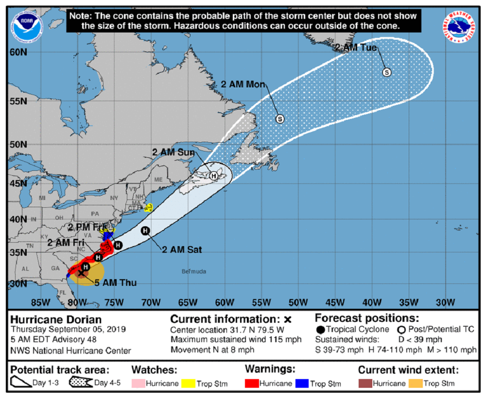
Because of the potential for winds to reach 39 mph or higher, there is a tropical storm watch posted for Cape Cod and the Islands. Winds of this speed can bring some scattered power outages. Some gusts could be over 50 mph if the storm comes close enough.
One thing that is for sure is seas will become rough. There could be some ferry service disruption, as well as strong riptides.
The system will still be close Saturday morning. I think the day starts with a lot of clouds and some rain. This is true especially south of Boston, but we will see improvement from the northwest toward the southeast throughout the day. Sunday is going to be the pick of the weekend, with mostly sunshine and temperatures rebounding into the mid-70s. For Cape Cod, Saturday is a washout in the morning if the track predicted holds.
It looks like the upcoming week will feature temperatures under 80 degrees and this will be the first time we've seen an entire week without reaching 80 since the middle of May.
You can follow my updates here and on Twitter @growingwisdom.
Thursday: Partly to mostly sunny. Cooler. Highs 72-77.
Thursday night: Mainly clear and cool. Lows 52-58.
Friday: Becoming cloudy after morning sunshine, a few showers. Possible downpours south. Breezy coast. Highs in the 60s to near 70.
Saturday: Early clouds, showers. Especially south. Sunshine and some clouds developing. Highs in the low 70s.
Sunday: Partly sunny and dry. Highs within a few degrees of 75.
