Support WBUR
Forecast: Hurricane Arthur May Bring Heavy Rains To Boston
Update: Hurricane Arthur has weakened to a Category 1 storm after hitting the coast of North Carolina Friday.
After just getting through the Boston Pops concert last night before a quick downpour but without any significant weather issues, things are going to slide quickly downhill the rest of the day.
While there are a few showers on the radar, the bulk of the rain is going to hold off until this afternoon and overnight when Hurricane Arthur, in whatever form it is by then, passes by.
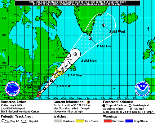
Arthur is now located over open water east of the mid-Atlantic coastline and moving northeast. It will make it's closest pass to New England late tonight or in the wee hours of Saturday morning. As of 5 a.m., the latest wind speed was still 100 miles per hour, making Hurricane Arthur a Category 2 storm.
The main wind shield will stay out to sea and only pose a problem for mariners. However, seas are certainly rough, and there will be some wind over Cape Cod, Nantucket and the Vineyard, but nothing more than a typical winter storm.
The words tropical storm warning are posted for those areas, but that term only means winds will reach 39 miles per hour or higher. At those wind speeds, there might be some minor power outages and a few trees down, but this storm isn't a big wind event.
Rainfall will come fast and hard and some areas near the southeast coast could see up to 4 inches of rain. This is enough to cause some street and small stream flooding.
The system pulls away late tonight and then our weather clears very early Saturday leaving us with a great weekend.
If you live in Cape Cod and Nantucket you should be sure your boat is secure and take in any lawn furniture that is light and could blow around.
Friday: Scattered showers and thunderstorms, especially in the afternoon. Several hours of dry weather between any storms during the morning. Warm and muggy. High near 80. Some of the storms could produce heavy rain and frequent lightning.
Friday night: Showers and storms, some of the rain could be heavy. Winds will be gusty over Cape Cod and the Islands, where a tropical storm warning is posted.
Saturday: Early clouds south of Boston, then becoming sunny and pleasant. Highs 77-82.
Sunday: Sunny and warm with low humidity. Highs 80-85.
Sunday night: A few clouds and more humidity. Lows 62-68.
Monday: Mostly sunny and warm with highs in the mid to upper 80s.
Monday: A blend of clouds and sunshine. Chance of afternoon showers and storms. Highs in the mid 80s with high levels of humidity.
Follow updates from David Epstein on Twitter @growingwisdom.
This article was originally published on July 04, 2014.
