Advertisement
Mass. Braces For Late-Winter Snowstorm
Massachusetts is preparing for a late-winter storm that could drop up to 2 feet of snow on parts of the state, with blizzard conditions forecast for some areas.
The National Weather Service has issued a blizzard warning for western, central and northeastern Massachusetts from 8 a.m. to 8 p.m. Tuesday. Boston and the southeastern parts of the state are under a winter storm warning from 5 a.m. to 5 p.m., and a high wind warning has been issued for the Cape and Islands from 8 a.m. to 6 p.m.
Snow is expected to begin falling between 5 a.m. and 7 a.m. Tuesday. Forecasters say the snow will quickly become heavy, with snowfall rates of 2 to 4 inches per hour possible, especially in the late morning and into the afternoon.
Boston is expected to see 12 to 18 inches of snow, while Worcester could see 18 to 24 inches. Southeastern Massachusetts and the Cape and Islands will see less snowfall, where a changeover to sleet and rain is expected. Plymouth is forecast to get 4 to 6 inches of snow, and Provincetown 3 to 4 inches.
There is also the potential for minor to moderate coastal flooding along the eastern Massachusetts coastline early Tuesday afternoon and just after midnight Wednesday.
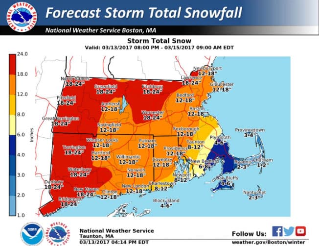
Dozens of communities have already cancelled school Tuesday, including Boston and Worcester. A snow emergency parking ban starts in Boston at 7 a.m. Tuesday.
During a press conference Monday, Gov. Charlie Baker urged residents to stay off the roads and use public transportation if they need to travel.
"The message we've been getting from the National Weather Service and others is that the storm is going to start and when it starts it's going to snow hard and it's going to snow quickly, and it's going to create very treacherous circumstances and conditions in many parts of Massachusetts," Baker said.
MBTA officials say the agency's goal is to maintain a normal weekday schedule Tuesday, with some exceptions. The Mattapan Trolley will be replaced by buses at the start of service Tuesday, ferry service will be suspended all day, and the commuter rail will operate on a severe weather schedule. Officials also warned of likely bus route delays and suspensions during the height of the storm.
Airlines have already canceled more than 500 flights to and from Logan Airport because of the forecast. Massport says it expects that airlines will cancel all operations at Logan Tuesday, with the exception of some early morning flights.
The storm will wrap up between 8 p.m. and midnight. Wednesday will bring more cold temperatures, with a high of 32.
This article was originally published on March 13, 2017.