Advertisement
Forecast: Florence's Remnant Rain Arrives Tuesday In New England
Most areas saw temperatures in the 80s on Sunday, which is about 10 to 15 degrees above average. Today will once again be another warm day once we get rid of any early morning fog and low clouds. Humidity will continue to be moderate — not excessively high but certainly noticeable in the air.
The remnants of Florence are now moving off toward the north and will eventually cross New England Tuesday. This is not going to bring about anything significant in terms of wind; however, there will be a narrow band of heavy rain with the potential for some street and urban flooding.
The best chance for the heaviest rain looks to be from the Massachusetts Turnpike northward. Whether or not the area sets up around the Pike or up around the Route 2 corridor is still a little bit questionable. The rain will move through rather quickly, however, because there will be downpours. Some places could exceed two or three inches of rain.
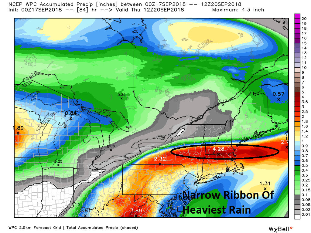
On the south side of this system, it will be more showery and there will be less total rainfall. All of us are going to contend with very humid air Tuesday — dew points once again rise into the 70s. The good news is this will not last, with drier air closely following.
The middle of the week looks quite nice, with seasonal temperatures and some crisp, dry air. This means that the mornings will be rather cool and it will be a great time for sleeping.
Another weather system moves into the area on Friday with the chance for more showers in a brief period of humidity lasting only a few hours. It turns drier and quite nice for the early part of the weekend.
You can follow my updates here and on Twitter @growingwisdom.
Monday: Early fog then sunshine, some clouds. Highs 77-81.
Monday Night: Muggy and warm. Late showers. Lows 64-68.
Tuesday: Showers and some tropical downpours. Highs in the mid-70s. Very humid.
Wednesday: Clouds, some sun cooler and drier. Highs nearing 70.
Thursday: Sunshine and clouds, highs 65-70.
Friday: Sunshine and clouds. May shower. Highs 70-75.
Saturday: Sun and clouds. Quite pleasant. Highs in the upper 60s.
