Advertisement
Nor'easter set to bring rain, snow and high winds to Mass.
The party's not over yet, winter enthusiasts! A storm system is set to bring rain, wind and some snow to Massachusetts, depending on where you live. Here's what you need to know.
Timing
Pockets of rain will fill in over the course of Wednesday morning, with wind gusts picking up along the coast. Steadier rain arrives Wednesday afternoon and evening, making your evening drive a slow go.
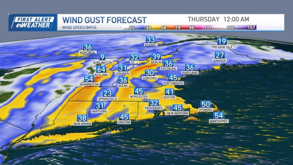
The "peak" of the storm will be Wednesday night into early Thursday. Strong east to northeast winds will be whipping through, with gusts reaching up to 45 mph regionwide and some gusts up to 55 mph at the coast, resulting in pockets of damage.
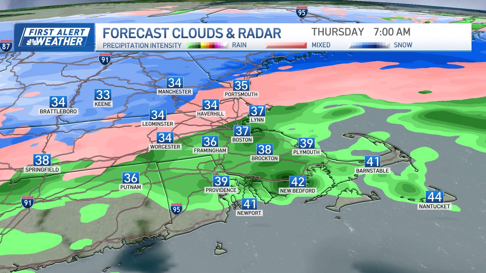
After dark Wednesday, with just enough cold air in place, rain will mix with sleet at times either side of the Mass. Pike in the north and transition to snow in the higher elevations in Worcester County, southwest New Hampshire. This will make the Thursday early morning commute a bit of a mess, with some slippery travel through the interior and wet roads and puddles elsewhere.
In a post on social media, Logan Airport officials warned travelers to expect flight delays Wednesday and Thursday as a result of the storm.
In terms of rainfall totals, this will be a widespread 1 to 3 inch event. Between 2 to 2.5 inches is anticipated in Boston. Renewed rises on area rivers will leading to some minor flooding, urban flooding and localized poor drainage Wednesday night into early Thursday.
By Friday, the nor'easter will weaken into a remnant low-pressure system, slowly drifting away to the east. Our weather will gradually improve, with cool temperatures in the upper 30s and low 40s and some passing rain and snow showers (little impact and no accumulation anticipated) Friday and Saturday. We can expect some sunshine to peek through on Saturday and Sunday.
On the coast
Keep an eye on the water levels. Strong winds and rising tides are the other main concerns. Expect peak winds from late Wednesday afternoon through early Thursday morning, with gusts exceeding 50 mph possible in some coastal areas. High tides on Thursday morning could reach minor to potentially moderate flood stages, particularly from Hampton, New Hampshire down to Gloucester, Boston, and the Islands. Thankfully, the flooding shouldn't be as severe as flood events in January or March due to lower astronomical tides this month.
Snow
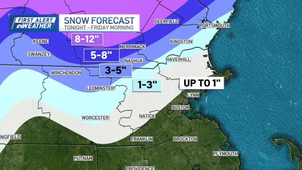
Now for the snow lovers. For southern New England, the chance of accumulating snow is highest in northern Worcester County and southern New Hampshire. And this event will be elevation dependent. Meanwhile, some parts of central and northern New England will see over a foot of snow! Great spring skiing is certainly going to be extended thanks to this storm. The snow will be on the heavier side, so some pockets of damage will be possible due to the wetter consistency in the jackpot zones.
Next week
Looking ahead, Monday's solar eclipse remains on track for mostly clear skies, followed by a fantastic week of weather. Temperatures will climb into the 60s next week, with a chance of reaching the 70s by the end of the week or next weekend.