Support WBUR
Live Blog: Irene Hits Mass.
[coveritlive title="" code="aa542902b7" width="315" height="385" align="right"]aa542902b7[/coveritlive]
The News: Irene — now a tropical storm — descended on New England, causing widespread power outages, tree damage and flooding in Massachusetts.
- National Weather Service: Complete Hurricane Irene forecast
- Stormpulse Map: Track Hurricane Irene
- Resources: Hurricane preparedness information for all of Massachusetts
- Resources: Specific preparedness information for Cape Cod and the Islands
- Twitter: Our list of local meteorologists
- National View: Though Worst Of Irene Over, Flooding Still A Concern
Our live blog begins below. Refresh for the latest; newest on top.
Update at 9:00 p.m.:
Scattered updates from the evening:
- The AP reports that 21 people are now confirmed to have died because of Irene.
- At 9 p.m., MEMA said 600,000 Massachusetts residents were without power.
- Most MBTA service will operate on a normal weekday schedule tomorrow.
- Monday Amtrak cancellations for Boston and Springfield trains are here.
Update at 5:00 p.m.:
As Tropical Storm Irene moves into northern New England and her wind levels continue to die down, let's recap today's headlines:
- As of 4 p.m., more than 500,000 Massachusetts residents were without power, according to MEMA's tally. National Grid, the utility with the largest number of reported outages, told us it will take days for power to be restored completely. (And that was when there were "just" 300,000 outages statewide.)
- With higher rainfall totals, western Massachusetts bore the brunt of flooding, and some residents had to be evacuated. In eastern Massachusetts, however, we are keeping an eye on possible coastal flooding associated with this evening's high tide.
- No Irene-related deaths or serious injuries have been reported in Massachusetts.
Update at 4:15 p.m.:
At 4 p.m., officials now say 400,000 Massachusetts residents are without power. MEMA just updated the total to 500,000.
Update at 3:51 p.m.:
Meteorologist Mark Rosenthal says he's still keeping an eye on the southern part of the state as we head into the evening:
I'm very concerned about the next high tide on the New England south coast early this evening because winds will be shifting around from the south-southwest, blowing 30 to 65 mph and that may make for some moderate to perhaps severe coastal flooding.
Update at 3:36 p.m.:

What's your neighborhood like? Tweet us your photos @WBUR or submit them to our Flickr group.
Update at 3:08 p.m.:
Power outages in Boston proper have been scattered, but a few hundred Bostonians in Hyde Park and Dorchester are still without power. Boston Mayor Thomas Menino is one of those left in the dark.
Though he's without power, Menino is still impressed by the city's disaster response.
"Everybody has worked real well together, we all cooperated," Menino told WBUR. "We got help from MEMA, we got help from the MBTA, we're all working together to get through this."
Update at 3:08 p.m.:
This hour, there are some 320,000 without power statewide. National Grid told our newsroom it's going to take days for the utility to get power back on for everyone.
Update at 2:31 p.m.:

We have some great photos of the tropical storm in this slideshow.
Update at 2:09 p.m.:
Heavy rains are proving troublesome in western Massachusetts, as some dams struggle to hold an increase in water. From State Police:
A dam in the western Mass. town of Becket, in a location known as the Sherwood Forest, has burst causing localized flooding. Fortunately, the area is not densely populated.
The Bear Swamp Dam in the town of Rowe, near the Vermont border, has also spilled over. State Police have responded to both locations.
Update at 2:06 p.m.:
Tropical Storm Irene has forced evacuations in some western Massachusetts towns, including Charlemont, Ashford and North Adams. A flash flood warning has also been issued for Franklin and Hampshire Counties.
MEMA's Scott MacLeod said further evacuations may be necessary.
Update at 2:01 p.m.:
@jcourtsull tweeted about Irene impact in Milton:
Power outages in Milton. On Garden St. several trees & wires down, a telephone pole down & more teetering. No way to drive off street.
Update at 1:51 p.m.:
Meteorologist Mark Rosenthal said winds in Boston are still gusting over 50 miles per hour.
Update at 1:30 p.m.:
Now, 330,000 power outages reported.
Update at 1:05 p.m.:
MEMA's Scott MacLeod offered this last hour:
The good news is through this morning's hide tide on the south coast, there were some reported road closures on coastal roads and some splash-over, but we're not seeing or hearing any real significant reports of infrastructure damage from the coastal impact.
But McLeod says hide tide later tonight could be a bigger concern for the coast.
Update at 12:58 p.m.:
From an interview with State Police spokesman Dave Procopio:
The biggest problems we're dealing with now are numerous downed trees and power lines, numerous areas of flooding, most severe in western and central Massachusetts.
Update at 12:47 p.m.:
Another jump: We're now reporting nearly 225,000 power outages statewide.
Update at 12:35 p.m.:
WCVB-TV's Kelley Tuthill tweets this picture of sea swells down in Edgartown:
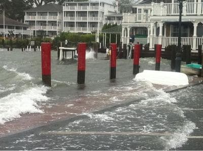
Update at 12:23 p.m.:
According to the AP, Irene had led to the deaths of 14 people in six states, as of Sunday morning.
Update at 12:22 p.m:
Irene knocked WBUR-FM offline for about 7 seconds.
Update at 12:05 p.m.:
HULL, Mass. (AP) - State police say a surfer who refused to leave Nantasket Beach in Hull has been arrested.
Update at 11:56 a.m.:
Some traffic alerts from State Police:
State and Wellesley Police have responded to an electrical wire that has come down on the roadway on Route 9 at Weston Road. Traffic is being diverted until the electric company can make repairs.
Troopers from the South Boston Barracks have CLOSED Morrissey Boulevard in Dorchester because of flooding. Traffic is being detoured.
Update at 11:48 a.m.:
NPR reports: Homeland Security Secretary Janet Napolitano said while there's still a long way to go, "it's safe to say the worst of the storm has passed."
But Boston City Councilor Ayanna Pressley reminds us that Irene is dangerous here, while sending along this picture of a crushed car in Jamaica Plain.
Update at 11:35 a.m.:
Irene's eye prepares to enter Connecticut on its way to western Massachusetts. Last hour, Gov. Deval Patrick told us a concern is that Irene’s path will go right through communities that were hit by the June 1 tornadoes. A lot of people still have tarps on their roofs and should find safe shelter, he advised.
Update at 11:27 a.m.:
WBUR's Delores Handy sends in this picture of downed trees on Centervale Park in Dorchester:
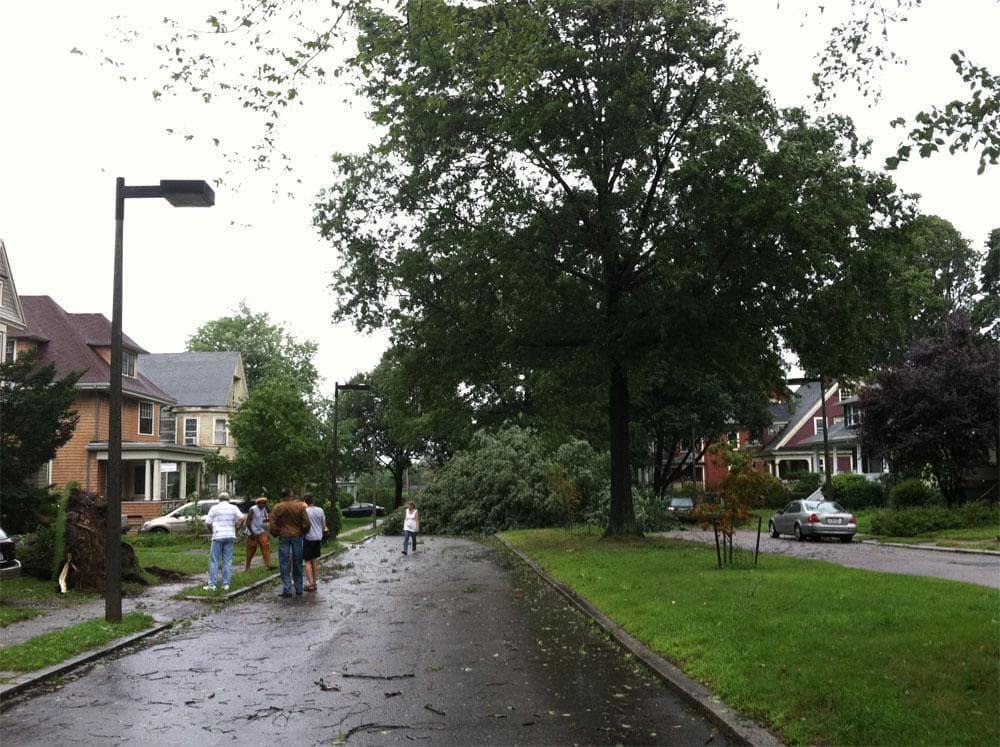
Update at 11:17 a.m.:
We just did another tally. There are now nearly 147,000 outages statewide.
Update at 11:15 a.m.:
WBUR's Curt Nickisch is in Fairhaven where he said the wind “literally takes your breath away,” but that hasn’t stopped people from coming out to get a look at the storm. He reported that at one point spectators had to lay down on the ground because the wind got so strong.
Update at 11:10 a.m.:
@neilemartin tweets us this great picture from Newton:
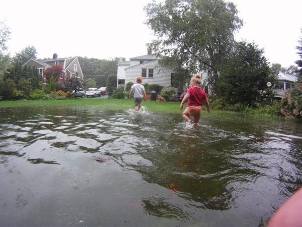
Update at 11:03 a.m.:
Where is Irene? The eye passed through New York last hour, but not before leaving knee-deep water in lower Manhattan, apparently.
Update at 10:50 a.m.:
These numbers just jumped. Now there are more than 125,000 outages across the state.
The numbers could even be higher, according to MEMA officials, since Western Mass. Electric Co.'s website is down. MEMA is estimating that WEMCO's outages total between 35,000 and 50,000.
Update at 10:17 a.m.:
The total number of power outages in Massachusetts has reached nearly 55,000. National Grid is reporting over 35,000, NSTAR approximately 14,000 and Western Massachusetts Electric Co. reporting just under 5,000.
Update 10:17 a.m.:
The Massachusetts State Police is reporting that the level of the Westfield River in Chester is rising quickly, causing flooding on Route 20. As a result, some residents are being evacuated. The Farmington River in Otis is flooded as well, causing road closures on Routes 23 and 8.
Update 9:28 a.m.:
As we wrote last night, the T is shut down today. General Manager Richard Davey told us this morning that the MBTA's main repair concern is wind but they are also watching for possible flooding in stations and tunnels.
Davey said the goal is for "seemless rush hour service" Monday morning. As of right now the MBTA plans to start service as it normally would on Monday morning.
Update 9:17 a.m.:
WBUR’s Jesse Costa is on Nantasket Beach in Hull, where one surfer was taking advantage of the storm Sunday morning.

Update 9:09 a.m.:
NSTAR is now reporting approximately 14,000 outages, bringing the total number without power across the state to more than 33,000.
Update 9:05 a.m.:
The National Hurricane Center has officially downgraded Irene to a tropical storm as the center of the storm makes its way over New York City:
IRENE HAS WEAKENED TO A TROPICAL STORM AND THE ESTIMATED INTENSITY AT LANDFALL WAS 65 MPH.
Update at 9 a.m.:
National Grid is reporting 16,502 of its customers are without power and Western Massachusetts Electric Co. is reporting almost 2,628 are without power. NSTAR is reporting scattered outages.
Update at 8:55 a.m.
The American Red Cross has a map of where to find open shelters in your area. MEMA also has a list of local shelters on their website.
Update at 8:47 a.m.
The City of Boston is asking residents to report down trees and limbs as soon as possible:
@NotifyBoston: Some early reports of down trees and limbs. Report ASAP to Mayor’s Hotline at 617-635-4500 #MAIrene
Update at 8:35 a.m.:
WBUR’s @CurtNickisch just tweeted a photo of onlookers in Fairhaven:
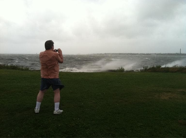
Update at 8:23 a.m.:
WBUR's Fred Thys sent this photo in of The Mayflower Shop in Chatham at 7 a.m., boarded up but not taking the day off.

Update at 7:58 a.m.:
The National Hurricane Center tweeted Irene's location as it continues on after its early morning landfall in New Jersey:
@NHC_Atlantic tweeted: Hurricane #Irene Intermediate advisory 32A issued. Center of Irene nearing new york city. http://go.usa.gov/W3H
NECN is reporting the storm is bringing winds of 75 miles per hour.
Update at 7:45 a.m.:
National Grid is reporting 9,742 of its customers are without power and Western Massachusetts Electric Co. is reporting almost 973 are without power. NSTAR is reporting scattered outages.
Update at 7:12 a.m.:
NECN is reporting one possible fatality and 200,000 without power in Connecticut as the storm bears down on New England.
Update 6:45 a.m. Sunday:
Hurricane Irene made landfall along the New Jersey coast near Little Egg Inlet with 75-mph winds around 5:35 a.m. Sunday.
Update at 7:31 p.m.:
MEMA has several emergency shelters up and running for both people and animals. Find the full list of Massachusetts' emergency shelters here.
Update at 7:24 p.m.:
The MBTA is planning to shut down all services tomorrow.
@mbtaGM, the MBTA's official Twitter, tweeted:
All MBTA Service Suspended Sunday due to Hurricane Irene. All details here: bit.ly/nxdT1i #mbta
That means all bus, T and commuter rail services will be shuttered for the day.
Update at 5:01 p.m.:
While officials are asking residents to stay off the roads starting this evening, MassDOT just tweeted this:
Traffic Alert: NO tolls collected on I-90 Pike, Tobin Bridge, Ted Williams Tunnel from Midnight tonight thru 10pm Sunday. Stay home, safe.
Update at 4:45 p.m.:
This hour, Massachusetts is experiencing the first "feeder bands" of rain from Irene, as meteorologist Mark Rosenthal just said on our air.
These rains can be quite heavy, and they've prompted flash flood warnings for much of eastern Massachusetts.
Update at 3:20 p.m.:
During his midday availability, Gov. Deval Patrick providing the following update, per the AP:
... Patrick said Irene’s main track northward had shifted inland, just to the west of Springfield.
With winds at their worst east of the storm’s center, Patrick said the forecast was calling for sustained winds up to 90 mph in Worcester County and 70 mph on Cape Cod. Four to eight foot surges were predicted on the state’s southern coast, while the worst rainfall, up to a foot total, was predicted in the westernmost parts of the state, the governor said.
Update at 2:50 p.m.:
The first Hurricane Irene-related deaths have been reported. Three have died in North Carolina and one in Virginia, according to reports.
Update at 12:10 p.m.:
The BSO's Tanglewood performance on Sunday — its final performance of the season — has been canceled. It's the first cancellation in the BSO's 75 years at Tanglewood.
Update at 11:45 a.m.:
Boston.com has developed a pretty cool interactive graphic that shows how hard Irene's winds are forecast to hit individual communities, and when.
Elsewhere, check out Google's hurricane map, on which you can overlay hurricane warning/watch areas and storm surge probabilities, and the Weather Channel Social, which allows you to track the latest weather tweets by city.
Update at 10:15 a.m.:
In an email, the MBTA says it still has "no plans to alter service at this time." Amtrak, however, has cancelled a number of East Coast trains.
Update at 9:10 a.m. Saturday: As Irene starts bashing the East Coast — now as a Category 1 storm with 92 mile-per-hour winds — here's our latest timetable:
- Irene is predicted to make landfall in Massachusetts and southern New England on Sunday. We will start to feel the impact of the storm beginning Saturday night.
At the time of this posting, no mandatory evacuations had been ordered. President Obama also this morning declared a state of emergency for Massachusetts, meaning federal aid will be available to supplement state and local efforts.
Update at 6:50 p.m.:
We'll close the live blog for the evening with the latest forecast from meteorologist Mark Rosenthal:
Update at 5:50 p.m.:
More on the Massachusetts warnings and watches, from the National Weather Service:
A HURRICANE WARNING IS IN EFFECT FOR THE FOLLOWING LOCATIONS: SOUTHERN BRISTOL MA; SOUTHERN PLYMOUTH MA; BARNSTABLE MA; DUKES MA; and NANTUCKET MA.
See NWS for the locations under a tropical storm warning.
Update at: 5:40 p.m.:
NECN meteorologist Matt Noyes updates:
Hurricane Watch now HURRICANE WARNING coast of CT, RI and Cape Cod/Islands.
A warning means hurricane conditions are expected within 36 hours.
Update at: 5:10 p.m.:
The Cape Cod Times has a list of Cape emergency shelters.
Update at 4:30 p.m.:
WBUR's Curt Nickisch reports on the potential losses Irene could deal local farmers and fishermen.
Update at 4:19 p.m.:
The Herald's Jessica Heslam takes a look at the outsize role meteorologists play in such weather:
Over at WHDH-TV (Ch. 7), Pete Bouchard said it’s a fine line to walk. “You’ve got to be informative,” he said, “but you can’t panic.”
Update at 4:13 p.m.:
At this point, Logan Airport plans to stay open, but it's up to the individual carriers to decide when to fly. And JetBlue today said it plans to close Boston operations Sunday.
In other closure news, all state-run parks, beaches, campgrounds and other recreation areas will close at noon tomorrow (Saturday).
Update at 4:08 p.m.:
For those of you with kids, @BostonLogan tweets:
Hurricanes can be difficult for young children to understand. Check out these preparedness tips from @sesamestreet
Kermit as a weather reporter, Oscar the Grouch being grouchy, Al Roker the weatherman — it's too good to pass up. FEMA has a Hurricanes For Kids website, too. It's on our list of online hurricane preparedness resources.
Update at 3:59 p.m.:
And speaking of Bob (from the Globe):
“This could come close to rivaling Bob,” said Bill Simpson, a meteorologist at the weather service office in Taunton, referring to the hurricane ... that caused hundreds of millions of dollars in damage and six fatalities in Southern New England.
Update at 3:45 p.m.:
How about a little Bay State hurricane history? This morning, WBUR's Lynn Jolicoeur took a look back at 1991's Hurricane Bob. But what about way back? On Flickr, Jim Burke has three images of train damage after the deadly Hurricane of 1938 swept through Medford. (h/t @universalhub) (Update: Or, maybe two images?)
Update at 3:15 p.m.:
Meteorologist Mark Rosenthal clarifies his wind-speed prediction for us:
We’ve always thought that the Cape and Islands would see very strong winds, and I would not be surprised if some spots on the Cape gust to 100 miles an hour. But it also really brings the potential for hurricane-force winds into the greater Boston area — 75 miles per hour or greater.
Update at 2:36 p.m.:
WBZ-TV meteorologist Terry Eliasen tweets this:
#Irene timeframe speeding up...worst of storm 5am-5pm Sunday
Update at 1:52 p.m.:
WBUR's Monica Brady-Myerov passes along this photo of MEMA's sample hurricane kit:

(Look at that phone!)
Update at 1:45 p.m.:
In his news conference from the emergency management bunker, Gov. Deval Patrick declared a state of emergency and said he's called up 2,500 members of the Massachusetts National Guard.
The state of emergency will continue throughout the weekend.
Patrick asked that folks stay indoors and off the roads, starting tomorrow (Saturday) night.
Update at 1:05 p.m.:
Just in, from the AP:
VINEYARD HAVEN, Mass. (AP) - White House says Obama to end vacation Friday, instead of Saturday, because of hurricane
Update at 1:02 p.m.:
Unless conditions significantly deteriorate, the MBTA is planning on normal weekend service this weekend. It's also increasing staff and tested emergency power sources.
Update at 1:00 p.m. Friday:
This hour, we're waiting for Gov. Deval Patrick's news conference from the state's emergency management bunker in Framingham. Ahead of his appearance, here's today's Irene headlines, so far:
- Patrick has activated 500 National Guard soldiers, according to the Boston Globe.
- The National Weather Service has posted a hurricane watch along coastal Massachusetts and a tropical storm watch for interior sections.
- Irene is currently a Category 2 hurricane with wind speeds at 105 miles per hour. She's in the Atlantic, parallel to Jacksonville, Fla.
This program aired on August 26, 2011. The audio for this program is not available.