Advertisement
Hurricane Bill Heads Toward Bermuda
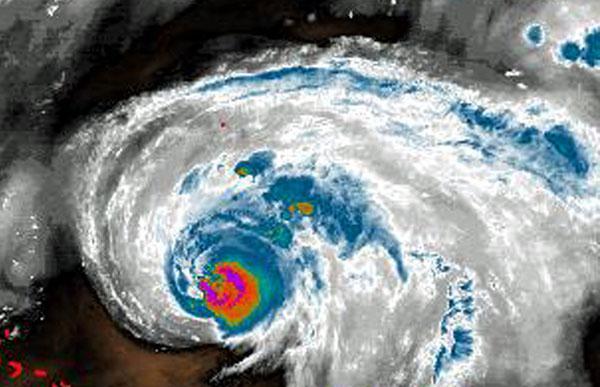
Hurricane Bill continued its slog across the Atlantic on Friday, threatening to flood Bermuda's coastlines and bring dangerous waves and riptides to the eastern U.S. coast.
The Category 3 storm's maximum sustained winds weakened slightly early Friday, decreasing to near 120 mph. Forecasters said the hurricane was becoming less organized but could still regain some strength. The storm was forecast to start gradually weakening Saturday.
Bill was expected to cause significant flooding along the Bermuda coastlines over Friday and Saturday and Bermuda issued a tropical storm warning. Dangerous waves and riptides were likely along most of the eastern U.S. coast over the weekend.
Bermuda's storm warning means winds of 40 mph or more were expected to arrive within a day, and the island remained under a hurricane watch that indicated even stronger winds were possible within 36 hours.
Thursday's warning came a day after former U.S. President Bill Clinton and his wife, Secretary of State Hillary Rodham Clinton, arrived in Bermuda on Wednesday for a 3- or 4-day getaway.
The government urged islanders to secure boats and finish other storm preparations by Friday afternoon. Officials put up warning signs at beaches along the south shore because of large swells and dangerous rip currents expected ahead of the storm. Home Affairs Minister Walter Roban urged people not to swim until further notice.
Some flight delays are possible, said Aaron Adderley, general manager of Bermuda's L.F. Wade International Airport.
"At this point, it's fair to say that one can expect some disruption - but to what extent, remains to be seen," he said.
At the 9 Beaches resort on Bermuda's western coast, general manager Robin Gilbert said some guests were leaving early but that roughly 100 were planning to stay.
Advertisement
"We're certainly going to have the bar open," said Gilbert, who added he's not expecting Bill's effects to be worse than what they'd get from a mild winter storm.
The storm's center is expected to pass between Bermuda and the U.S. eastern coast on Saturday. Forecasters said large swells from the storm were affecting Puerto Rico, Hispaniola, The Bahamas and Bermuda on Thursday. They warned that the swells could cause extremely dangerous surf and rip currents at beaches on one of the final weekends of summer.
"Those swells are known to be deadly," said Eric Blake, a hurricane specialist at the National Hurricane Center. "It's just going to be very dangerous this weekend."
The center's five-day track showed Bill staying well out to sea off the southern and northern U.S. coast. Bill was forecast to inch closer to shore as it moves north but only come close to landfall in Canada's Maritime provinces before veering back out into the North Atlantic.
At 5 a.m. EDT Friday, the storm was centered about 425 miles south of Bermuda, or about 865 miles southeast of Cape Hatteras, N.C., and was moving northwest around 17 mph.
Bill is the first Atlantic hurricane this year after a quiet start to the season that runs from June through November. The Miami center lowered its Atlantic hurricane outlook on Aug. 6 after no named tropical storms developed in the first two months.
The revised prediction was for three to six hurricanes, with one or two becoming major storms with winds over 110 mph. Researchers at Colorado State University have also lowered their Atlantic season forecast to four hurricanes, two of them major.
This program aired on August 20, 2009. The audio for this program is not available.