Support WBUR
Forecast: Over Next 3 Days, Snowfall Will Add Up To 'Impressive' Totals
Snow will fall at varying rates Sunday with light accumulation before dark. There can always be spots which have a bit more snow. Temperatures today will remain mostly in the 20s, and while cold, you’ll be able to move around.
Overnight snow will continue with some pockets of moderate to heavy snow. All areas will see plowable amounts of snow with the exception of Cape Cod where mild air will allow the precipitation to fall in the form of mostly rain.
Throughout this weather event, Cape Cod will remain too warm for much, if any accumulation, although areas closest to the canal could see an inch or two. Once you get further inland, snow will quickly pile up.
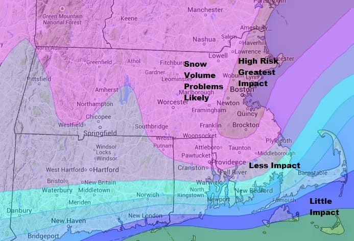
The persistent snowfall will impact three commutes — both of Monday’s rides home, as well as the Tuesday morning commute. The Tuesday evening commute will be better, but in those areas hardest hit snow removal will take several days to complete. Some of the narrowest streets may become impassible until snowbanks are hauled away.
Snow continues to fall all day Monday and into Monday evening. Part of coastal Massachusetts may not see the snow completely end until sunrise on Tuesday.
Such a long period of snowfall will allow the snow to add up to impressive amounts. Some areas will see over 2 feet of snow by the time it’s over. I recommend removing the snow in stages and not waiting until the snow has ceased.
South of Boston the snow will be wetter and heavier, but in most areas the snow will at least be on the lighter side.


Sunday: Snow likely. Highs in the 20s.
Sunday Night: Snow. Low around 15.
Monday: Snow. Winds will be brisk in the afternoon. Highs 25-35, mildest at the Cape and the Islands.
Tuesday: Clearing, then partly sunny. Highs in the lower 30s.
Wednesday: Mostly sunny, with a high near 25.
Thursday: A chance of more snow. Highs 25-29.
You can follow David’s weather updates on Twitter at @growingwisdom.
This article was originally published on February 08, 2015.
