Support WBUR
Forecast: Snowstorm Will Come To An End Late Tonight
Listen to Dave's weather update on WBUR's All Things Considered by clicking the play button above
When a snowstorm is about to hit I get asked when it will start and how much will fall. Once it is underway people want to know when it will end. Going south from Boston, the snow will begin to taper off during the mid-evening hours and then end west to east from about 10 p.m. Saturday evening to 1 a.m. Sunday morning.
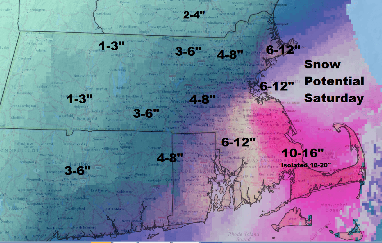
Snowfall amounts will range from 8-11 inches around the city of Boston with some spots hitting 12 inches and others only at 6-7 inches.
The highest totals will be over southeastern Massachusetts including parts of Cape Cod and the Islands. Some of those areas received up to 8 inches in just a few hours, so totals of 16 inches or more are likely. There could be a few snow showers from 1 a.m. to 4 a.m. over Cape Cod.
Snowfall should become lighter over the Route 495 belt until it is gone before midnight and along the coast just after that.
Sunday is cold and windy. Cleaning up will be easy due to the light weight of the snow — but not too easy thanks to the cold.
The weather turns milder by the middle of the week with melting temperatures in the 40s and lower 50s.
Our earlier post from Saturday morning:
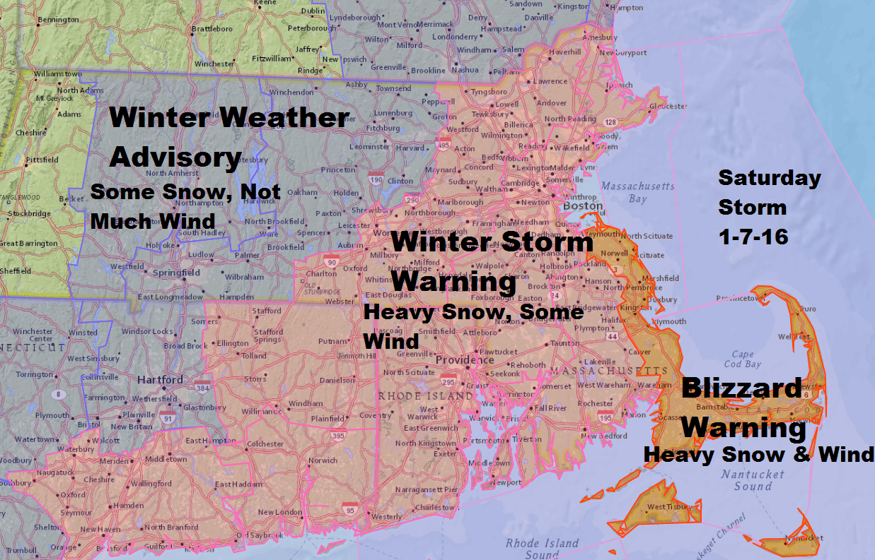
A difference of just 75 miles in the track of a big ocean storm can change a five day forecast from a chance of snow showers to a blizzard for some areas. This is the story Saturday with a blizzard warning posted south of Boston.
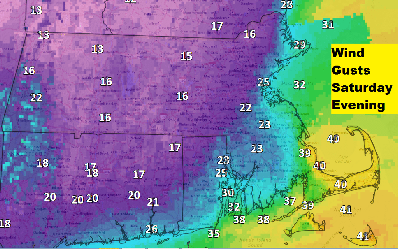
Remember, a blizzard is a technical term put in place to warn residents of the lack of visibility for at least three hours. We can have a blizzard with 4 inches of snow or 14. The warning is up because between about 4 p.m. and 11 p.m. Saturday there is likely going to be a period of time when the visibility lowers to a 1/4 mile or less for at least three hours due to the wind and snow. Under a blizzard, the winds must be 35 miles per hour in frequent gusts or simply sustained at that speed.
In Boston, I am still expecting simply a storm with lots of snow. On my maps, Boston and surrounding areas are in the 8-14 inch range. The snow will be very light — think, similar to the snow of February 2015. It will not be heavy, wet or hard to move, but there will be a lot of it.
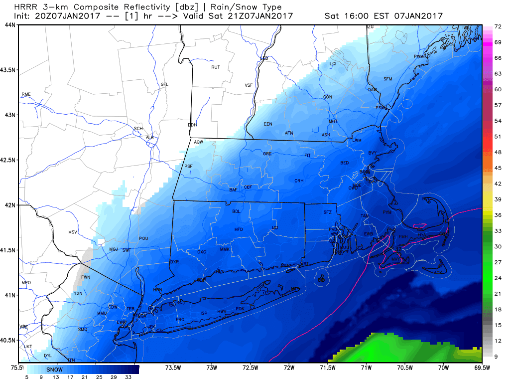
The snow will begin Saturday morning over Cape Cod and parts of the South Shore. This is due to the cold air rushing over the comparatively warm ocean waters. This is also the reason why these areas will see the heaviest snow totals. I don't expect a wide swath of 20 inches over this area, but due to the possibility of heavy bands of snow setting up, I have added that number to the map. These situations are analogous to lake effect snow and a difference of a few miles can be the difference of 6 inches of snow. If you live south of Boston along the coast, prepare for a large amount of snow. Boston itself should be in the 5-9 inch range.
In Boston, the snow will also start Saturday morning for the same reasons. Look for less intense snow, but there could be a coating to 2 inches of snow before noon.
Winds will be strong late this afternoon and evening. The snow will be whipped into large drifts and make it difficult if not nearly impossible to travel. Stay home this afternoon and overnight.
The bulk of the storm arrives after 12 p.m. and really ramps up late in the afternoon to about midnight. Remember, those are the times for the heaviest snow. Many areas will have seen snow falling for hours before the heaviest arrives. Those ocean bands could produce some moderate to heavy periods even this morning along the South Shore, Cape and the Islands. It's less likely Boston sees moderate snow in the morning but not out of the question.
Snow will wind down by midnight and temperatures will tumble into the teens and even upper single digits far north and west. Winds will be a factor into Sunday with temperatures only reaching around 20 degrees.
The cold lasts into Monday, but a January thaw starts Tuesday and lasts the rest of the work week.
Look for updates here and on Twitter @growingwisdom.
Saturday: Winter Storm Warning for Boston as snow develops. Continuing through the first part of the overnight. Look for several inches on the ground by sunset. Lesser amounts west of Route 128 and Route 495.
Saturday night: Snow ending by midnight. Lows 10-18.
Sunday: Partly cloudy and cold. Highs in the low-20s.
Monday: Sunny and cold. 19-24 in the afternoon.
Tuesday: Morning sunshine, then a chance of a showers late in the day. Not so cold. Highs 35-40.
This article was originally published on January 07, 2017.
