Support WBUR
Field Guide to Boston
What a potential La Niña winter means for New England
La Niña is looming. The climate phenomenon is predicted to return this fall, affecting weather across North America, especially during the winter months.
Here's a breakdown of how La Niña can affect our weather:
What is La Niña?
La Niña is a climate pattern that represents the cooler phase of the El Niño-Southern Oscillation cycle. It occurs when sea surface temperatures in the central and eastern Pacific Ocean drop below average, influencing global weather patterns. La Niña's counterpart, El Niño, is characterized by warmer-than-normal sea surface temperatures in the same region.
Currently, we are in a "neutral" phase, with expected La Niña conditions to take hold through the end of fall and persist perhaps into early spring.
While each La Niña event varies, certain predictable patterns emerge.
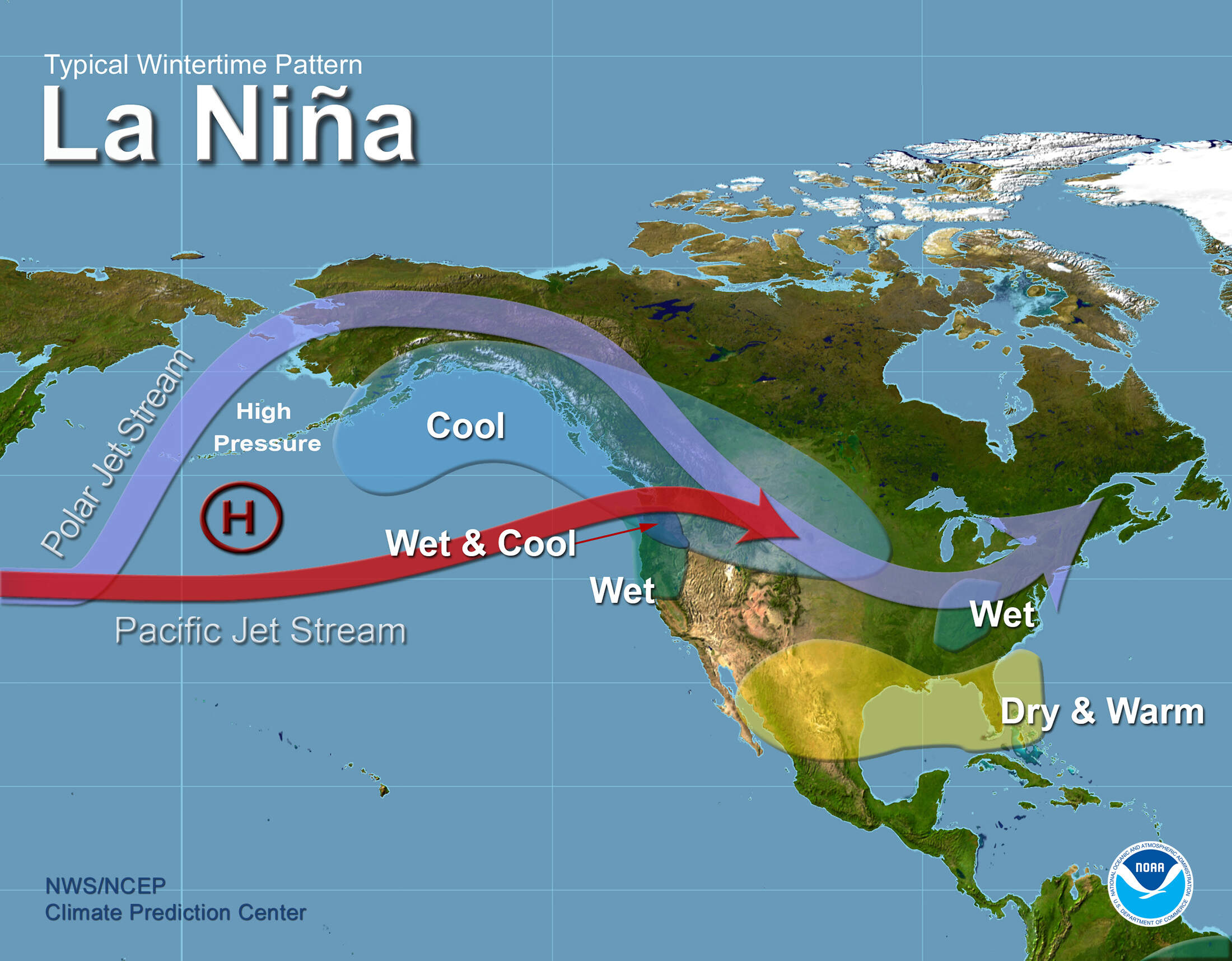
La Niña influences the weather across North America by shifting the jet stream. The jet stream is the river of air high in the sky that acts like a thermostat, separating cold air to the north and mild air to the south. During La Niña, the jet stream typically takes on a wave-like form and strong high pressure systems over the eastern North Pacific increase atmospheric blocking. In between, the clash of these air masses breeds storms, which are steered by the jet stream.
Although the jet stream’s strength can fluctuate, it often enters North America through the Northwestern U.S., leading to increased storm activity and above-average precipitation in the Ohio Valley, as storms are guided in that direction. The central U.S. also experiences more frequent cold air outbreaks, while the southern U.S. generally sees below average precipitation. These transitions can take several months.
How La Niña affects New England's fall and winter weather
In the Northeast, the jet stream shift often leads to colder, drier winters, as cooler air masses from the Arctic have easier access to the region.
Key impacts of La Niña on New England include:
Colder temperatures: During La Niña winters, New England often experiences below-average temperatures, especially in December through February. Cold air masses can settle in more frequently, leading to extended periods of chill.
Storms: New England sees a mix of dry periods and intense winter storms during La Niña. The storm track typically shifts farther north, meaning that while the southern U.S. experiences drier conditions, New England could see more frequent nor’easters or coastal storms.
Precipitation: La Niña can cause swings in precipitation. New England might see less frequent but more intense snowstorms, with the possibility of dry periods punctuated by significant snowfall events. While La Niña doesn’t guarantee more snow, the pattern favors snowier conditions in the northern parts of the region. While southern areas like Cape Cod might fluctuate between snow and mixed precipitation, leading to a below average season.
The bottom line? As we continue to transition to La Niña, New England is likely to experience shots of cold air from time to time and drier conditions this fall and winter, with the potential for significant winter storms when they do hit.
