Support WBUR
Subzero Super Bowl Sunday: Dangerously cold air will grip Mass. following pesky snow
You may want to run your Super Bowl party errands early.
Another Arctic airmass — straight from the North Pole — is headed toward New England this weekend, with strong winds that will make it feel like 10 to 30 degrees below zero in certain spots on Sunday. The cold front is also likely to drop another light but pesky layer of snow Saturday.
Here's what to know:
Saturday snow
This isn’t a blockbuster storm, but it’s absolutely the kind that causes headaches, especially because it’s cold enough for snow to stick quickly on untreated surfaces.
Expect 1 to 3 inches of snowfall around the state. Communities along the South Shore, eastern Essex County, and the Outer Cape may get around 4 inches.
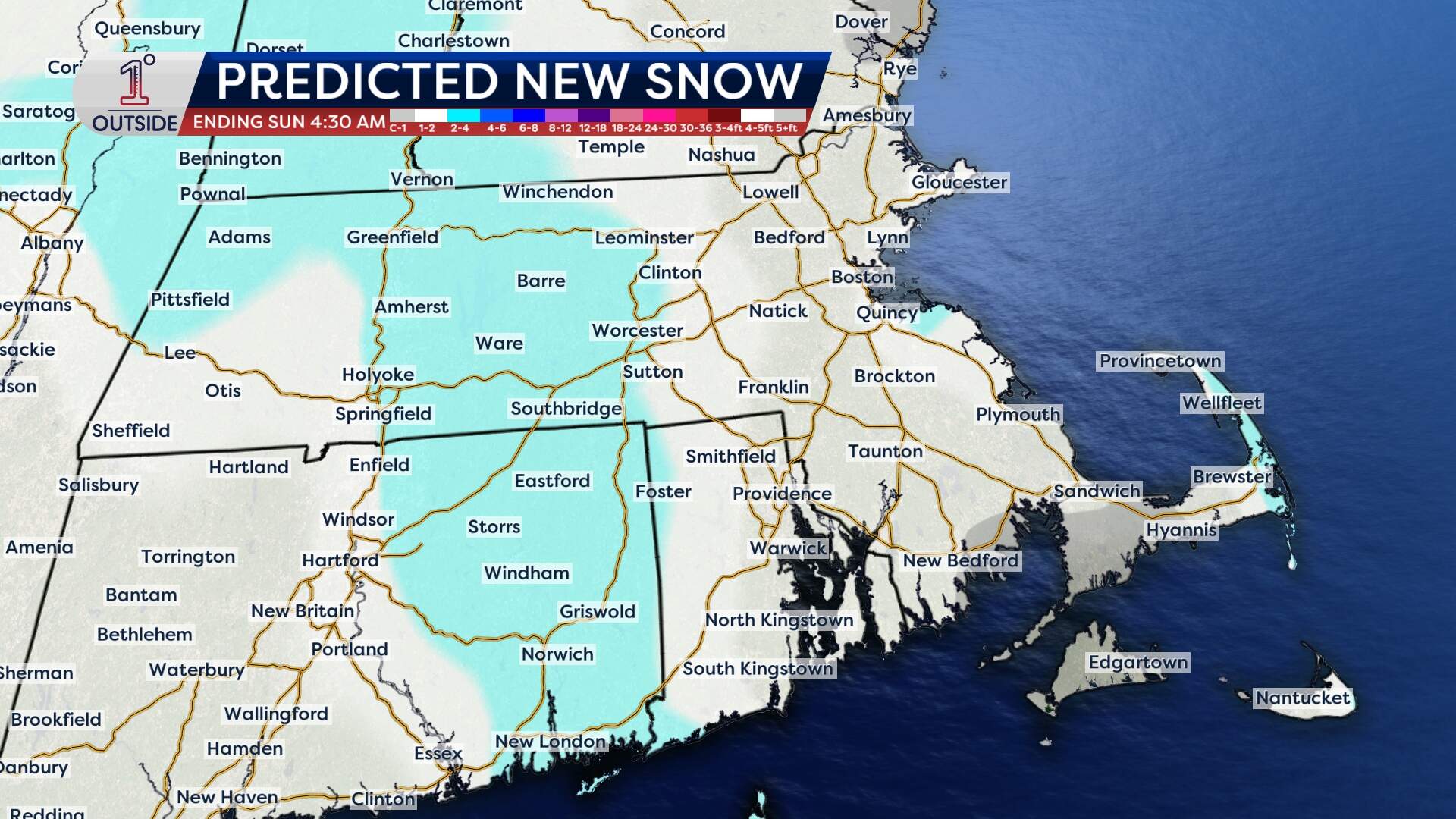
But it won't be snowing steadily all day. This system has some built-in “holes,” meaning periods of lighter snow or lulls will develop, especially Saturday afternoon.
When will the flakes start?
Most of Friday will be generally calm, but parts of Essex County, the South Shore and down toward Cape Cod will see intermittent ocean-effect flurries drift in off the water. The snow showers should be brief and light, but a coating can happen here and there.
More organized snow develops late Friday evening in western New England, then slowly spreads east overnight. The snow will be steadiest Saturday morning through the afternoon, as an Arctic front presses in. Snowfall will taper west to east, lingering longest toward the Cape.
Bottom line: plan for slower travel Saturday, especially in the morning and midday.
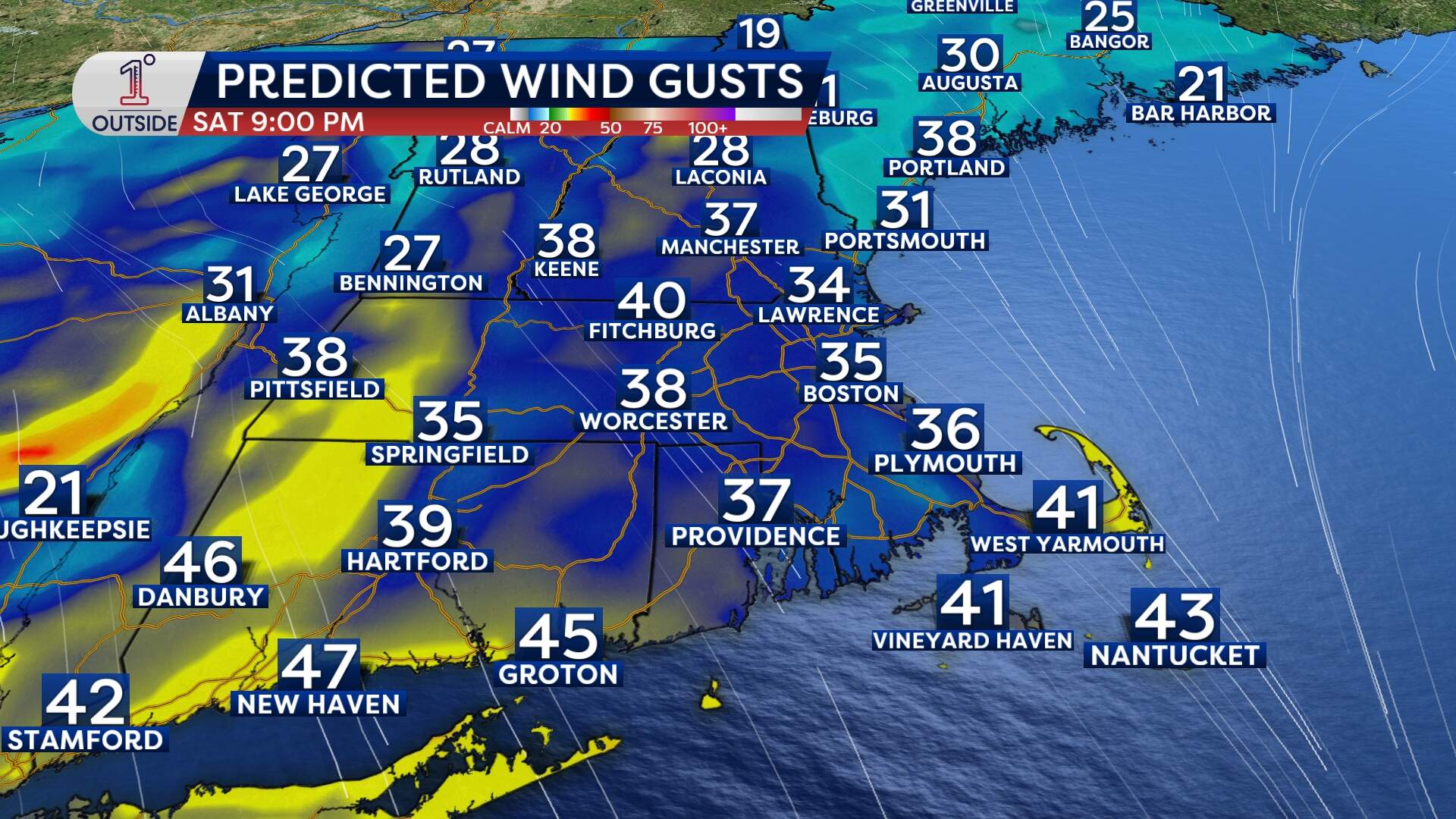
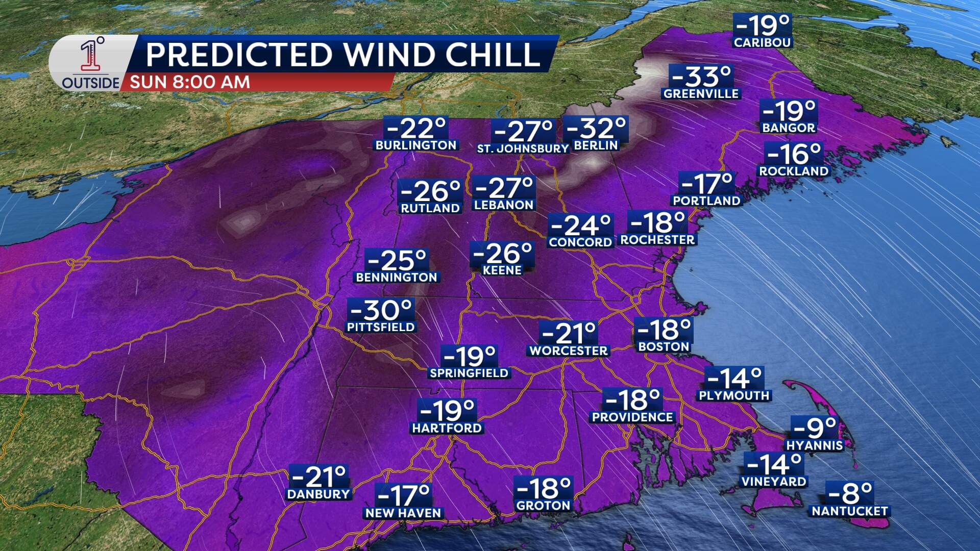
Dangerous cold moves in
As the Arctic front blasts through Saturday afternoon into Saturday night, wind gusts increase and temperatures drop quickly. That combination is what creates the bite.
Gusts ramp up Saturday afternoon and evening, with many areas seeing 30 to 40 mph. Some spots, especially higher terrain and parts of the Outer Cape, may see gusts push 40 to 45 mph.
Wind chills will start plunging Saturday afternoon and evening, first in western areas, then sweeping east. By Saturday evening into Sunday morning, many communities will see wind chill values of 10 to 20 below zero, with chills of minus 20 to minus 30 in the coldest interior and far northern spots.
Sunday's feels like values will hover around zero at the "warmest" time of the day, then drop into the minus 5 to minus 15 range Sunday night into Monday morning
In that kind of cold, exposed skin can become a problem quickly. Those going out for any length of time should cover up completely (especially fingers, ears and face.)
Practical prep: the quick checklist
There are a few things that matter during a cold snap like this:
- Cars: This is battery-killing cold. If a car battery is already weak, this is when it may end up dying.
- Pipes: Keep indoor temps steady. Consider opening cabinet doors under sinks on exterior walls to help warmer air circulate.
- Space heaters: Use them safely — keep heaters clear of anything flammable and never leave them unattended.
- Pets: Quick trips outside are fine, but don’t leave them out for extended stretches.
Get the latest updates at 1DegreeOutside.com or on the free 1DegreeOutside mobile app.
