Support WBUR
Major nor'easter bringing 1 to 2 feet of snow and heavy wind
A powerful nor’easter is bearing down on New England.
For eastern Massachusetts and the Boston area, the high-impact storm is bringing heavy snow, blizzard conditions, power outages as well as coastal wind and flooding.
The National Weather Service issued a blizzard warning that is in effect until 7 a.m. Tuesday.
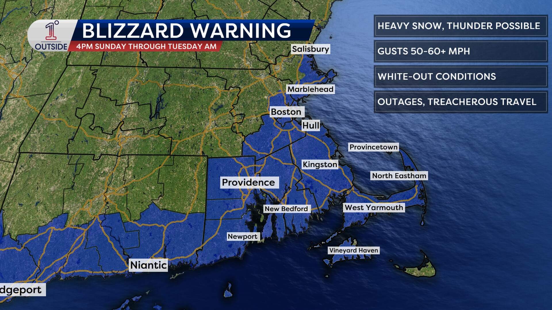
A blizzard has a specific definition: heavy falling or blowing snow reducing visibility to ¼ mile or less, plus frequent wind gusts of 35 mph or higher for at least three consecutive hours.
The warning area highlights where those ingredients overlap best — but even outside the formal warning, the remainder of central and eastern Massachusetts will still see bursts of near-whiteout visibility and dangerous drifting, Monday morning to midday.
When is the storm coming?
Sunday:
- Evening: Snow reaches Worcester and Providence around 7 p.m.; hitting Boston and along the South Shore around 8 p.m.
- Late evening: Snow expands north toward the Massachusetts-New Hampshire border around 9 to 10 p.m.
- Overnight: Snow intensity ramps up significantly; visibility begins to drop and roads become increasingly treacherous.
Monday:
- Pre-dawn through late afternoon: Peak impact from the storm, with the strongest winds and heaviest snow rates, 2 to 4 inches per hour. Thundersnow is possible during this window, too.
- Evening: Steady snow winds down by 7 to 9 p.m. from Worcester to Boston; blowing snow will linger as the wind slowly throttles back.
How much snow are we talking?
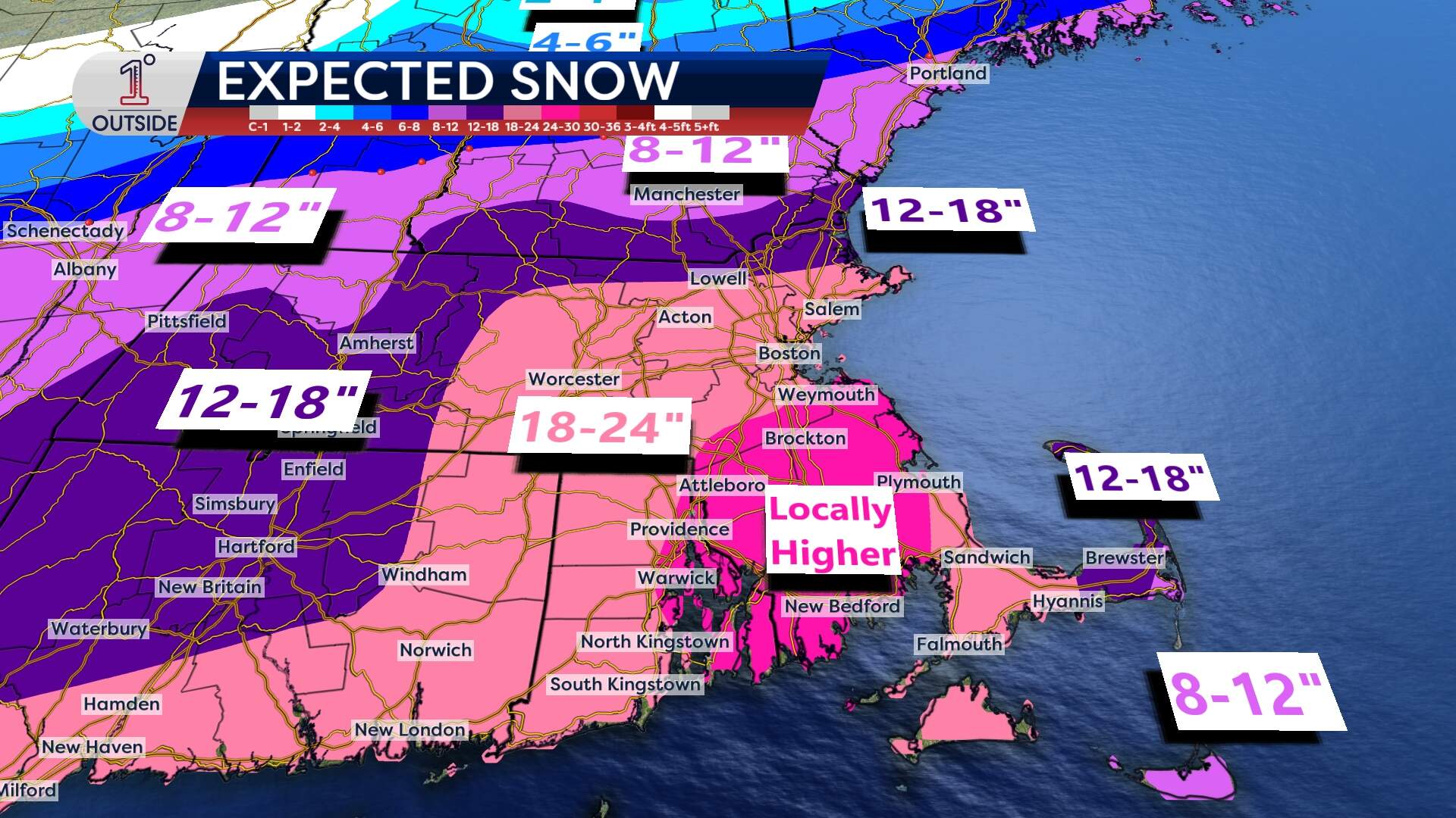
Snow totals look widespread and significant across southern New England, with the highest confidence in major accumulations in eastern Massachusetts.
- Greater Boston and nearby interior (including the Worcester-to-Boston corridor): 18 to 24 inches.
- Cape Cod: totals may run lower in spots if a brief mix sneaks in, but many communities still see plowable, impactful snow.
One important note: snowfall can vary sharply over short distances in storms like this. If a coastal front sets up near the shoreline, localized swaths can exceed surrounding totals with a rapid burst of heavier snow.
How hard is this going to be to shovel?
For the Boston area and especially the coastal plain (including the South Shore), snow may be heavier and wetter at times — the kind that sticks to branches and power lines. The combination of wet snow and wind is what raises the risk of outages. Inland, snow will be a bit lighter and more powdery.
What about the storm's other impacts?
Winds increase Sunday evening, then become strongest Monday pre-dawn into early afternoon.
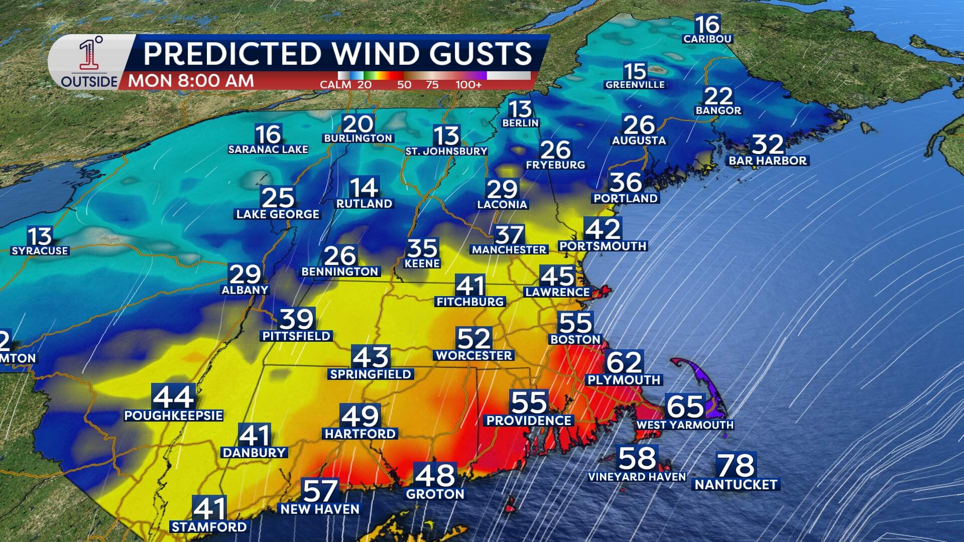
- Coast (including the Boston shoreline): gusts commonly 45 to 55 mph
- Cape Cod: gusts 55 to 65 mph, with higher gusts possible in the most exposed locations, to 75 mph
- Inland eastern Massachusetts, Rhode Island, Connecticut: gusts 30 to 40 mph, enough for significant blowing and drifting
Winds begin east/northeast, then turn north and eventually northwest late Monday as the storm pulls away. Expect blowing snow to become more pronounced even as snowfall rates decrease.
With strong onshore wind and building seas, the coast will be vulnerable to minor coastal flooding, with pockets of moderate flooding possible in the most susceptible locations. Expect the potential for splashover and debris on coastal roads, beach erosion, and road closures in the most exposed shoreline spots, around both high tides Monday.
The bottom line
Plan for a high-impact storm from Sunday night through Monday in Boston and southern New England, with very difficult to potentially impossible travel at times, especially overnight into Monday and through Monday afternoon.
If you have flexibility, the safest choice is to avoid travel during the peak. Prepare for the possibility of power outages.
For the latest forecast updates as things tighten up, check 1DegreeOutside.com or the free 1DegreeOutside mobile app.
This article was originally published on February 20, 2026.
This segment aired on February 21, 2026.
