Support WBUR
Forecast: More sloppy weather to create a slick evening and morning commute
It's the winter that just won't quit.
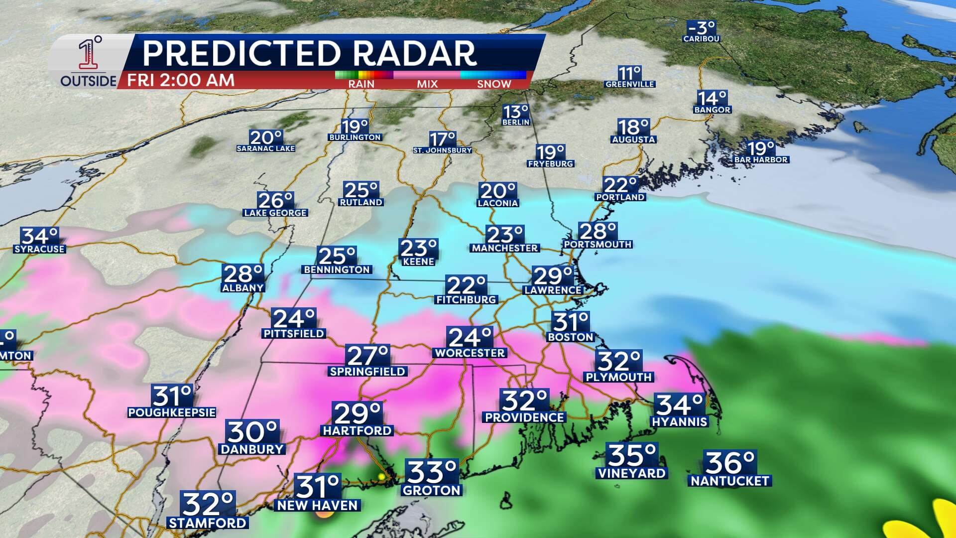
Another round of sloppy winter weather arrives Thursday, starting as rain for many and then changing to a wintry mix and snow for some overnight into early Friday.
The most important detail is that this isn’t a deep-freeze storm. It’s right on the edge, meaning the difference of a degree in temperature may produce varied precipitation type and therefore, amounts.
The forecast hinges on two main things:
- How quickly colder air can win out near the ground
- How hard the precipitation falls (heavier precipitation can cool the air faster and flip rain to snow)
Even a 1 to 2 hour earlier changeover can boost accumulation noticeably, especially north and northwest of Boston.
Timing and travel: when it gets messy
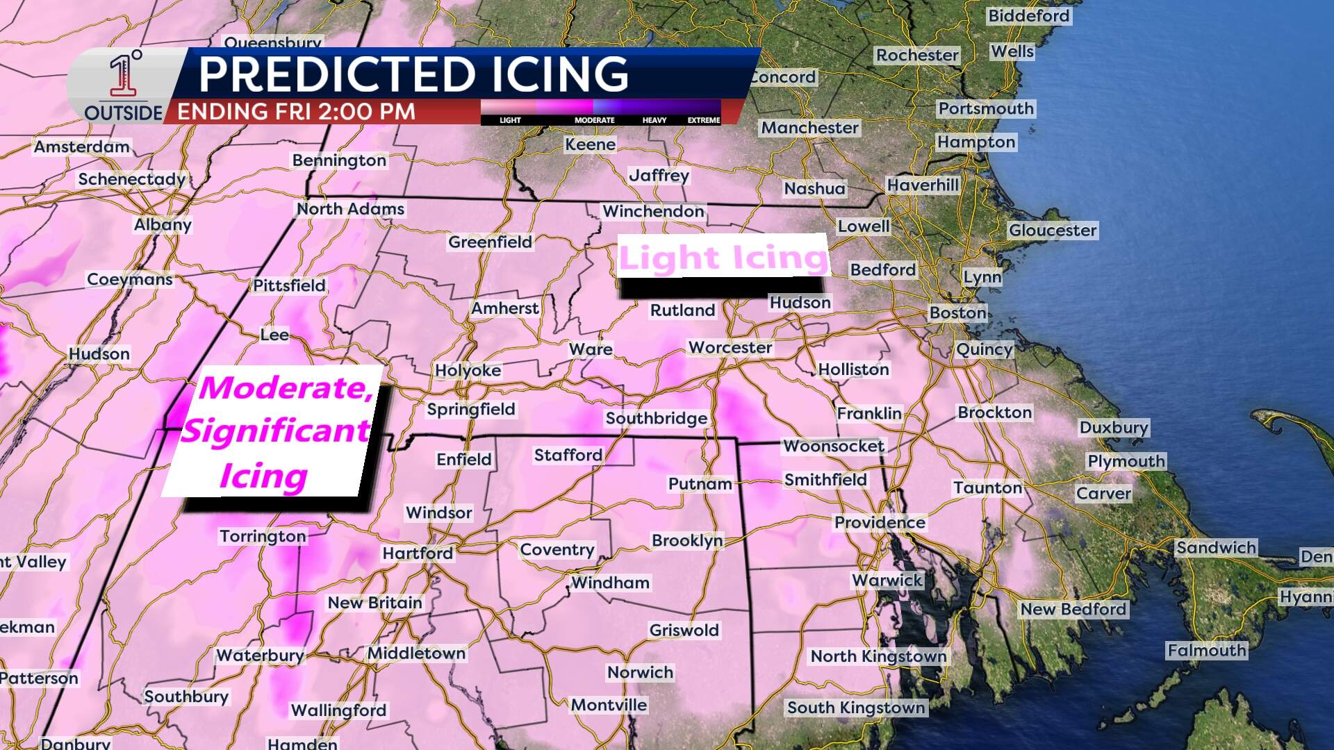
Late morning to early afternoon: Precipitation will first expand across Connecticut, Rhode Island and western and central Massachusetts. Interior cold pockets allow for some sleet and freezing rain, especially in higher terrain and sheltered valleys.
Late afternoon: The leading edge works into the Worcester to Boston stretch between 4 to 5 p.m., with sleet possible at the start for some inland locations. Along and south of the Mass Pike, the concern becomes mixing types of precipitation rather than big snow totals. This is still impactful, because mixed precipitation creates slick roads quickly.
Evening through overnight (highest impact): This is the window where rain and the mix will flip to wet snow in parts of eastern and northern Massachusetts, as temperatures hover around freezing and precipitation intensity increases. The risk of freezing rain is highest where surface temps sit at or just below 32 degrees while warmer air rides in aloft: this tends to favor southern Worcester County into northern Rhode Island.
Friday morning commute: The steadiest precipitation exits roughly between 5 and 8 a.m. from west to east. But temperatures will be 20s to low 30s, so whatever fell overnight will leave behind sloppy, slick, icy spots.
Even after precipitation ends, lingering low-level moisture will mean patchy freezing fog or freezing drizzle, especially north and west of Boston. This is one of the sneakier ways slippery travel lasts longer.
Where the snow adds up most (and where it doesn’t)
This forecast carries lower-than-usual confidence because the “accumulating snow stripe” is narrow and could wobble north or south.
Southern parts of Vermont, New Hampshire and Maine are the likely to get 2 to 4 inches of plowable snow. An area near the southern New Hampshire and northern Massachusetts border, including parts of the Merrimack Valley and near I-495, is most likely to get this accumulation.
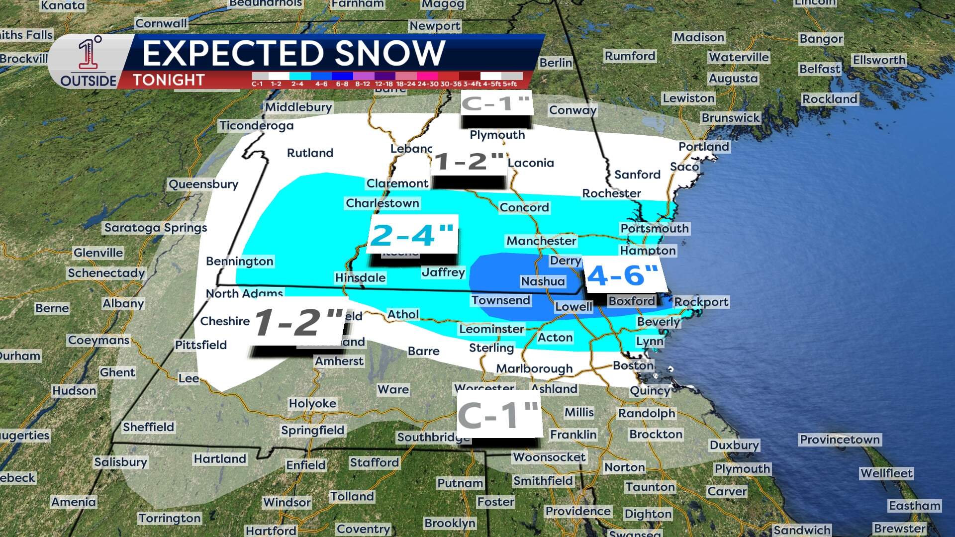
Boston and MetroWest may get 1 to 2 inches in the city and nearby suburbs if the changeover to snow happens late enough. If the flip to snow happens even a little earlier, totals may be nudged up a bit.
Along and south of the Mass Pike, especially in Connecticut, Rhode Island and southeastern Massachusetts, there is less of a snow risk, and more mix and ice risk. It doesn’t take much sleet or a light glaze to make roads dangerous.
The ice concern: small numbers, real impact
Ice amounts may sound “minor,” a few hundredths to perhaps one or two tenths of an inch in the more favored interior zones, but that’s enough to create slick untreated roads and sidewalks, isolated tree limb issues and spotty power interruptions.
Southeastern Massachusetts: don’t ignore the rain and drainage
One more important piece: 1 to 1.5 inches of rain in southeastern Massachusetts will result in some issues, because it’s falling on top of existing substantial snowpack.
That raises the risk of localized street and poor-drainage flooding, especially overnight into early Friday when runoff can’t move efficiently.
A few practical steps that genuinely help:
- Clear storm drains on your street, if you can do so safely
- Make sure gutters and downspouts are open
- Keep an eye out for water pooling that can refreeze as temps drop back toward freezing
What happens after: quieter, milder and trending warmer
After this system pulls away, the pattern looks fairly cooperative. Scattered rain showers are expected Saturday evening into Sunday. Otherwise, the weekend is relatively quiet and mild, with highs in the 40s and 50s. A bigger warm-up is possible heading into next week, with temperatures in the 60s possible.
Get the latest updates at 1DegreeOutside.com or on the free 1DegreeOutside mobile app.
