Support WBUR
Forecast: A wet, windy Monday ushers in a sharp temperature drop
Boston is in for a busy 24 hours of weather that will end with a jolt to the system just in time for St. Patrick’s Day.
From flood watches to high-wind warnings, here's what to know to navigate an impactful Monday in Massachusetts.
Wet weather Monday
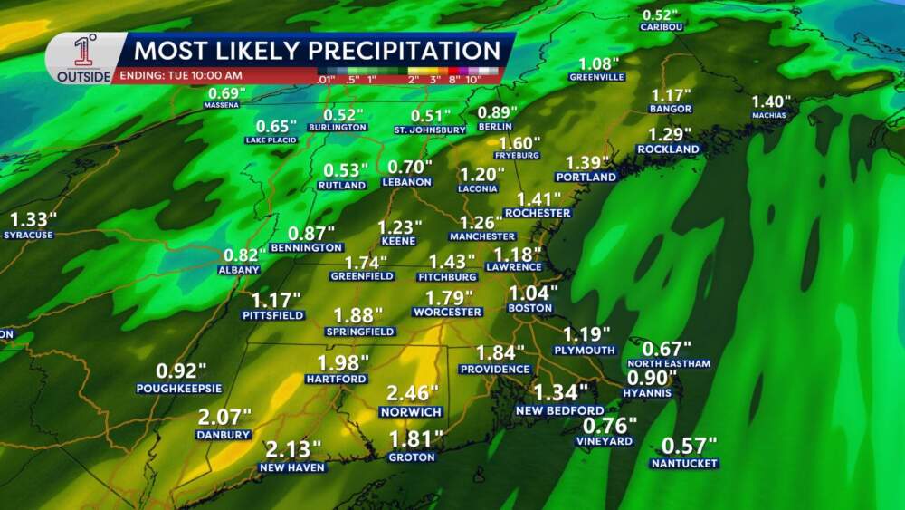
A widespread 1 to 3 inches of rain is expected across southern New England. While that’s usually manageable, the ground is currently saturated from snowmelt and previous storms.
- Expect minor flooding in poor-drainage urban areas and along several local rivers and small streams. In Massachusetts, keep a close eye on the Deerfield, Sudbury and Taunton basins in particular.
- This system has a good chunk of energy with it, which will promote the risk of thunderstorms throughout the day and into the night.
- Monday is a classic “pothole day.” This is the kind of early spring soaking that finds every weakness left behind by a long winter of plowing and road salt. Between the heavy rain and poor drainage, deep puddles will form and aren't just a hydroplaning risk — they are often hiding deep, tire-popping potholes.
Damaging winds overnight
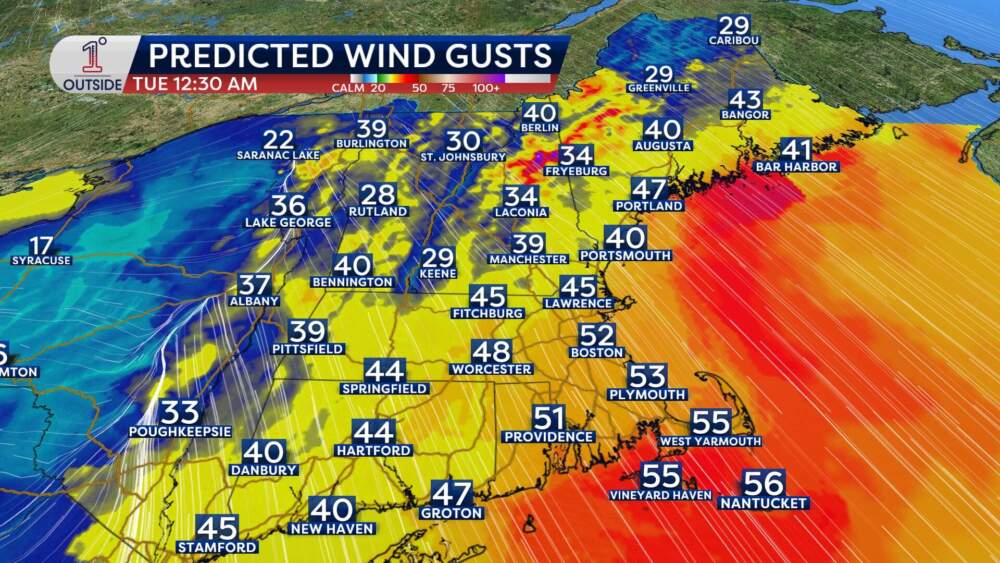
The height of the storm arrives Monday evening, and as the cold front sweeps through, the wind will ramp up significantly.
- The numbers: Widespread gusts of 40 to 50 mph are likely. However, from Eastern Essex County down to Cape Cod, we could see gusts hitting 50–60 mph.
- The impact: Unlike a winter nor'easter, there won't be heavy snow weighing down branches. However, the ground is incredibly soft and wet, making it much easier for trees to uproot. Expect scattered power outages and damage.
The St. Patrick’s Day switch
By Tuesday morning for St. Patrick's Day, the rain will be gone, but the air will feel entirely different.
The cold front will usher in a sharp drop in temperature. Boston will go from near 60 degrees Monday to a Tuesday that is breezy and significantly colder (40s). Wednesday will be the coldest day of the week, with highs struggling to even reach the upper 30s. The bottom line:
- Charge up: Keep phones and devices charged this evening in case of localized outages during the midnight wind peak.
- Drainage: For those with a storm drain near their house that’s blocked by leftover winter debris, clearing it now could prevent basement flooding later Monday.
- Timing: The rain may end with a quick burst of snow in the far northern and western parts of New England. But for Boston, it’s a liquid event followed by colder air. Don't worry too much about the moisture freezing up as the wind will dry out wet spots fairly quickly and the temperature doesn't drop below freezing until Tuesday evening.
Get the latest updates at 1DegreeOutside.com or on the free 1DegreeOutside mobile app.