Support WBUR
Dramatic warm-up coming: 70s and 80s this weekend, 90 possible Tuesday
If you have been waiting for the weather to truly turn the corner, your patience is about to pay off. A substantial pattern shift is underway, bringing a dramatic warm-up and our first real taste of summer heat and humidity over the coming days.
Here is a breakdown of what's heading our way and a peek at some potentially record-breaking warmth on the horizon.
A weekend 'behind schedule' (but worth the wait)
The transition begins this weekend. Temperatures will climb well into the 70s on Saturday, with many spots reaching into the lower 80s by Sunday afternoon.
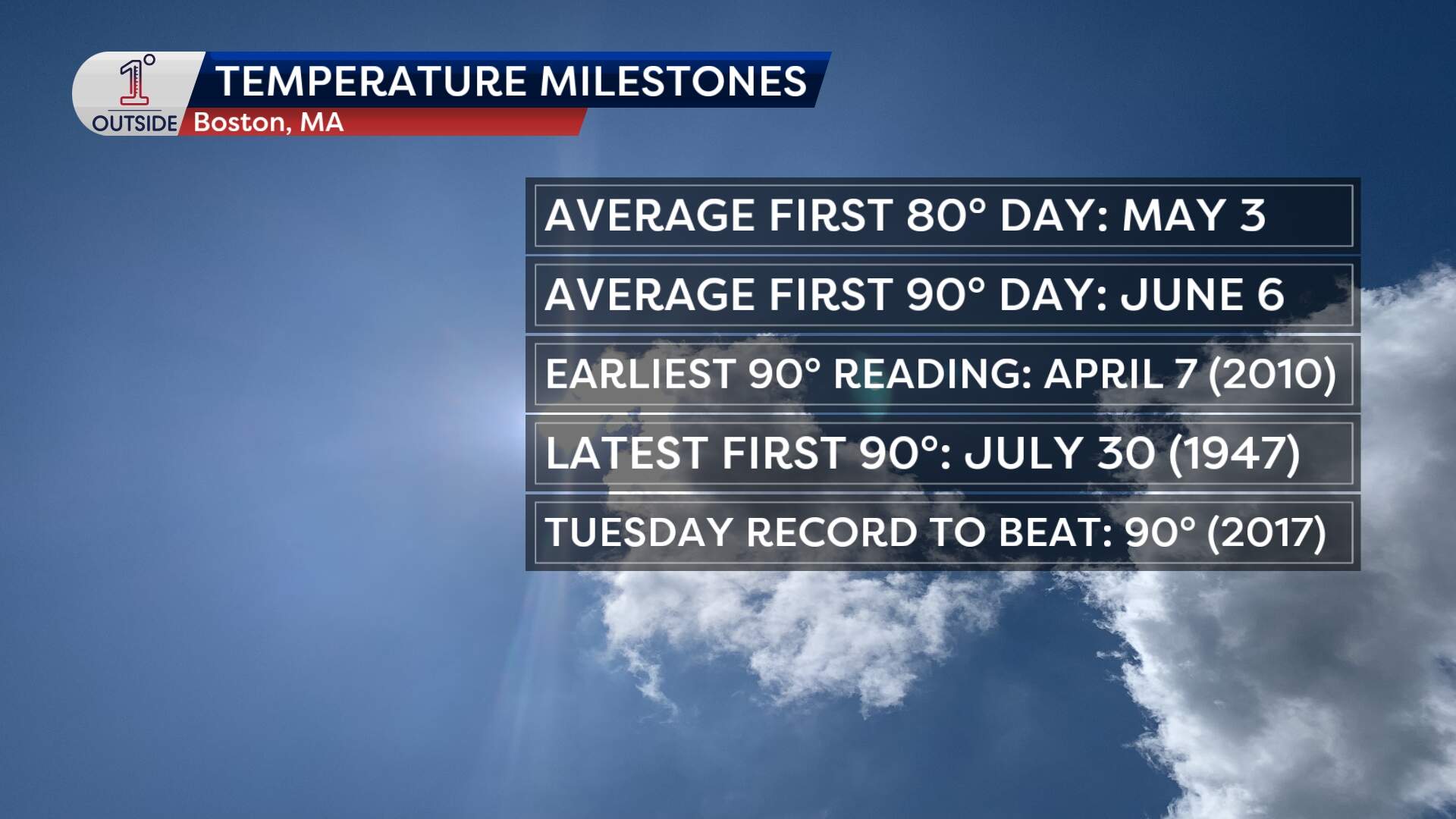
If it feels like a long time has passed since you experienced that kind of warmth, you aren't imagining things. Boston has yet to hit the 80-degree mark so far this spring. Statistically, the city reaches its first 80-degree day around May 3. We are running a bit behind schedule this year — but we'll make up for lost time in short order.
Flipping the switch to summer
A cold front arrives Sunday night into Monday, which will temporarily knock temperatures back into the 60s along the immediate coastline Monday (though inland areas will hold onto the 70s).
By Tuesday, a ridge of high pressure will pump unseasonably hot air right into the Northeast. Highs on Tuesday are likely to soar well into the 80s across the region. There is even a chance— about a 20% chance right now — that Boston could cross the 90-degree threshold. If we manage to hit 90, it will be the earliest we've seen a 90-degree reading in the calendar year since 2018.
It won’t just be hot, either; it will feel notably different. Tuesday will deliver our first real dose of summer humidity. While it won't be the oppressive, mid-August "soup," dewpoints climbing into the low 60s will certainly provide an unmistakable sticky feel.
Eyeing the record books
Tuesday's heat wave isn’t just a local story. The expansive dome of warmth will be stretching across the Ohio Valley, the Mid-Atlantic and right into our backyard, putting daily record highs in jeopardy across multiple states.
Locally, the daily record high to beat in Boston on Tuesday is 90 degrees, a milestone set back in 2017. Given our current setup, we have a genuine statistical run at matching or breaking it.
The cool-down uncertainty
How long does the preview of summer last? That depends entirely on a cold front scheduled to arrive around mid-next week. Right now, there's some disagreement on the exact timing of this front:
- The slower scenario: If the front slows down, the unseasonable warmth and humidity could easily linger through Wednesday and potentially even Thursday.
- The faster scenario: If the front moves with a bit more urgency, we will see a significant, rapid drop in temperatures back by later Wednesday.
As is typical when a sharp cold front collides with a hot, humid airmass, this boundary will likely trigger some scattered showers and thunderstorms. We'll track the atmospheric elements closely over the next few days and keep you updated on the exact timing of those storms and the subsequent cool-down.
Until then, grab the flip flops and summer clothes, pull out the air conditioner, and enjoy the beautiful summer preview this weekend!
Track the forecast for your city or town in the free 1DegreeOutside weather app.
