Advertisement
Winter Weather Returns To Mass. After Mild Stretch
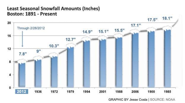
In a winter that just won't snow, a two-day storm taking a swipe at Massachusetts will continue Thursday as mostly rain in Boston and areas south of the city. Areas north and west of the city could see another 2 to 3 inches of accumulation before the storm winds down.
[sidebar title="Weather Links:" width="260" align="right"]
[/sidebar]
With temperatures in the mid to upper 30s across most of the state, snow will have a hard time continuing to accumulate Thursday. According to meteorologist Mark Rosenthal, Boston could see some light snow mix in as the storm lingers late Thursday, with another dusting to 1 inch possible.
"In the city of Boston we'll have occasional rain, it might flip over to some wet snow this afternoon, we'll have to watch that," Rosenthal said. "But once you move north city it's going to be a totally different world with snow falling for the afternoon drive home."
By the storm's end late Thursday, areas outside of I-495 and Route 128 will see approximately 6 to 8 inches of total snowfall, with totals increasing as you move west across the state. Areas south of Boston will continue to see mostly rain.
The National Weather Service’s winter weather advisory is slated to be in effect through 6 p.m. Thursday.
More than 150 schools either closed or delayed opening Thursday, while police reported dozens of minor spinouts and accidents on the roads. No serious injuries were reported.
There were no significant public transportation problems reported, though a number of flights at Logan International Airport were cancelled.
This article was originally published on March 01, 2012.