Advertisement
First Snow Of Season Will Impact Tuesday Morning Commute
After the warmest two day Christmas Eve and Christmas on record, it's back to the reality that we are less than a week away from January, and winter has to arrive at some point.
It's not going to be a big storm, but the first snow of the season always makes a big splash. The timing of this one is such that the morning commute Tuesday will be messy, especially coming into Boston from the north and west.
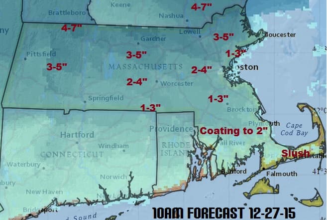
The map below shows how much snow I am expecting as of Sunday morning. This map is subject to change as new information arrives later today and Monday. The amounts could fluctuate based on if the cold air remains in place longer or shorter than I am expecting right now.
Low pressure is going to move west of New England, but a new storm will form on the coast on Tuesday morning. This will keep the cold air in place long enough to allow for accumulating snow.
The snow could come down quite hard between 4 a.m and 10 a.m. depending on your location. By early afternoon the snow will have ended or changed to rain and drizzle. Some melting will occur and I don't expect much in the way of icy roads, just slush.
FORECAST
Monday: Sunny, with a high near 36. North wind 10 to 13 mph.
Monday Night: Snow developing after midnight. Low around 27.
Tuesday: Rain, snow, and sleet, becoming all rain after noon. High near 40.
Wednesday: A chance of rain by sunset. Highs in the lower 40s.
