Advertisement
Today's Weather: It Will Be A Somewhat Unsettled, Wet Week
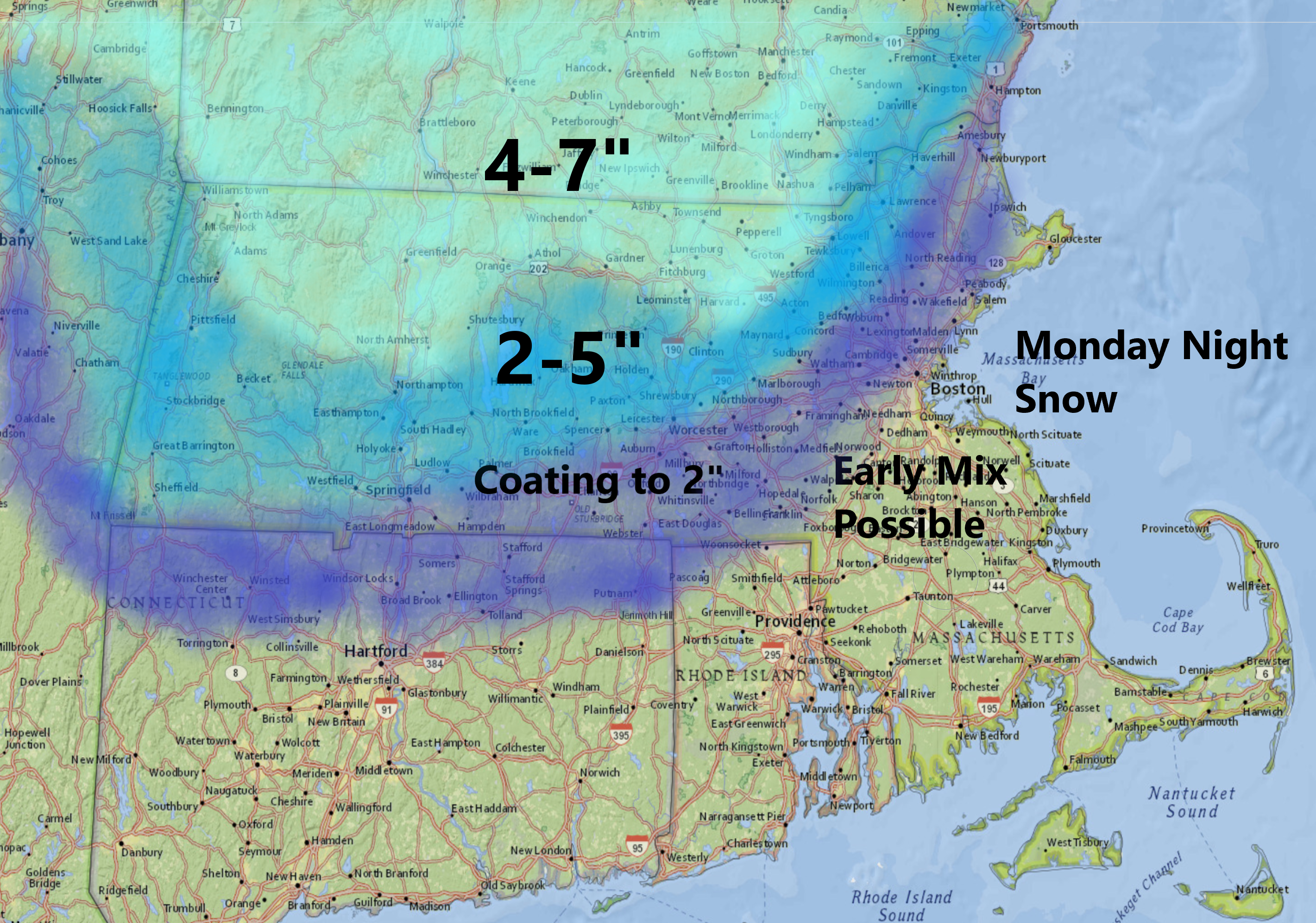
A coastal storm system moving toward Southern New England will bring thickening clouds and eventually rain and snow later today. Because temperatures will be cold enough, some of that snow will accumulate north and west of Route 495, especially in the higher elevations of the Route 2 corridor into New Hampshire and parts of Southern Vermont. If you're headed to Maine, there will also be accumulating snow mainly away from the coastline — although even there a couple of inches is likely.
Since ski areas are closed, the snow will not benefit spring skiing, but the higher elevations are likely to see 4 to 8 inches of snow.
Overnight the precipitation will accumulate, but likely change to rain before ending from east to west.
Accumulating snow is likely north and west of Route 495 overnight before a change to rain and ending early Tuesday.
On Tuesday, I'm expecting clearing skies and, if there are any lingering showers in the morning, they would quickly end just prior to sunrise. Temperatures will rebound into the 40s and lower 50s, meaning that any snow that did fall would melt away.
I still expect some of the higher elevations to see measurable snow and we'll take another look at that tomorrow. The rest of the week continues to feature systems moving quickly across the country. I don't think we're going to see any extended dry weather in the foreseeable future, but there will be a couple dry, mild days that will let you get outside and take a break from being in your homes.
You can follow my updates here and on Twitter @growingwisdom.
Monday: Clouding up, some snow north and west, but rain developing elsewhere later in the afternoon. Highs 35-40.
Monday night: Accumulating snow north and west of Route 495, a mix or rain closer to the coast.
Tuesday: Any early rain ends, then sun and clouds. Highs 48-53.
Tuesday night: Partly cloudy. Lows 32-37.
Wednesday: Clouding up, rain later in the afternoon again. Highs 45-50.
Thursday: A chance of snow showers early, then rain showers likely. Mostly cloudy, with temperatures in the mid to upper 40s late day.
Friday: Partly cloudy, blustery. Highs in the mid-50s.
Saturday: Sunshine and clouds. May shower, but seasonable. Highs near 50.
Sunday: Partial sunshine. Highs in the 50s.
