Support WBUR
Heavy, gusty nor'easter brings risk of outages and minor flooding
A potent nor'easter is heading our way Tuesday.
This storm is the result of a fast moving clipper system moving through the lower Great Lakes that will interact with a wave of low pressure coming off the coast of North Carolina Monday morning. The two will essentially merge and intensify in a process called "bombogenesis."
The center of the storm is likely to pass near or over Cape Cod Tuesday before strengthening then slowly moving east Tuesday night and Wednesday.
This is a multifaceted storm: rain, snow, wind and waves are anticipated across the region, depending on location. My biggest concern is for pockets of damage and outages due to the heavy, wet nature of the snow clinging to everything. This will also make cleanup difficult, so plan on a few rounds of shoveling as opposed to doing it all at the end.
Road conditions
Travel will be slow on Tuesday morning, but become increasingly difficult Tuesday from midday onward into the evening.
Snowfall rates of 1-2 inches per hour at times will create treacherous driving conditions on the roads. Travel is not advised during this timeframe.
With continued plowing and treatment, roads will improve dramatically Wednesday, though an additional round of treatment may be necessary Wednesday evening due to a little bit of melting and refreezing of untreated surfaces, and some lingering snow showers.
Timing
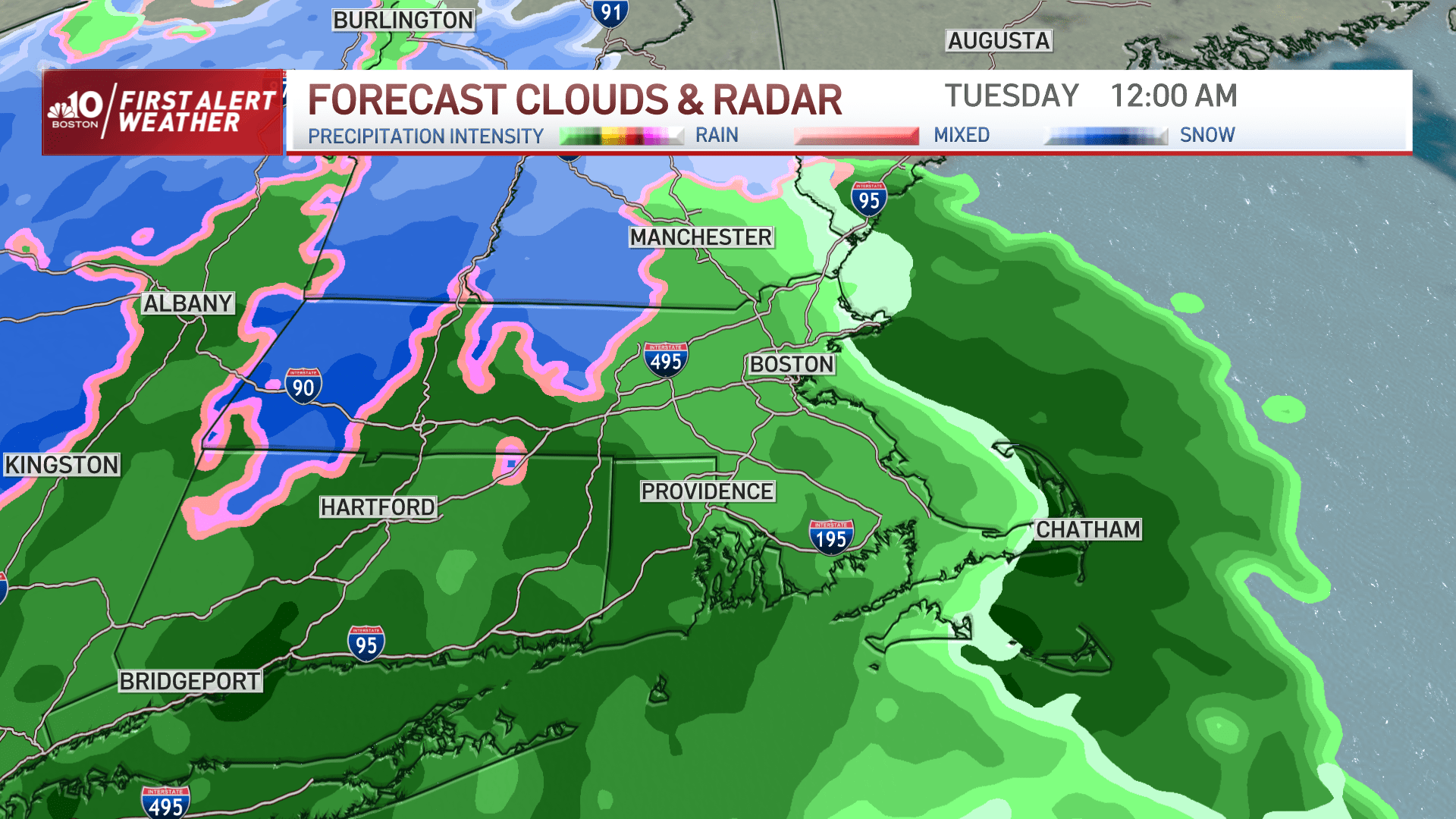
Clouds thicken and lower through the day Monday and high temperatures will be around or just over 40 degrees Fahrenheit. With marginal temperatures in place, this will mean rain for the city for several hours before a change to snow.
A few scattered light rain showers will be possible Monday evening before the steadier shield of rain moves in after that.
It will continue to rain through the first part of the overnight, with the rain/snow line positioned in central Massachusetts. The rain/snow line will collapse east Tuesday from late morning to early afternoon, so anticipate a change to snow in the city of Boston either side of noon.
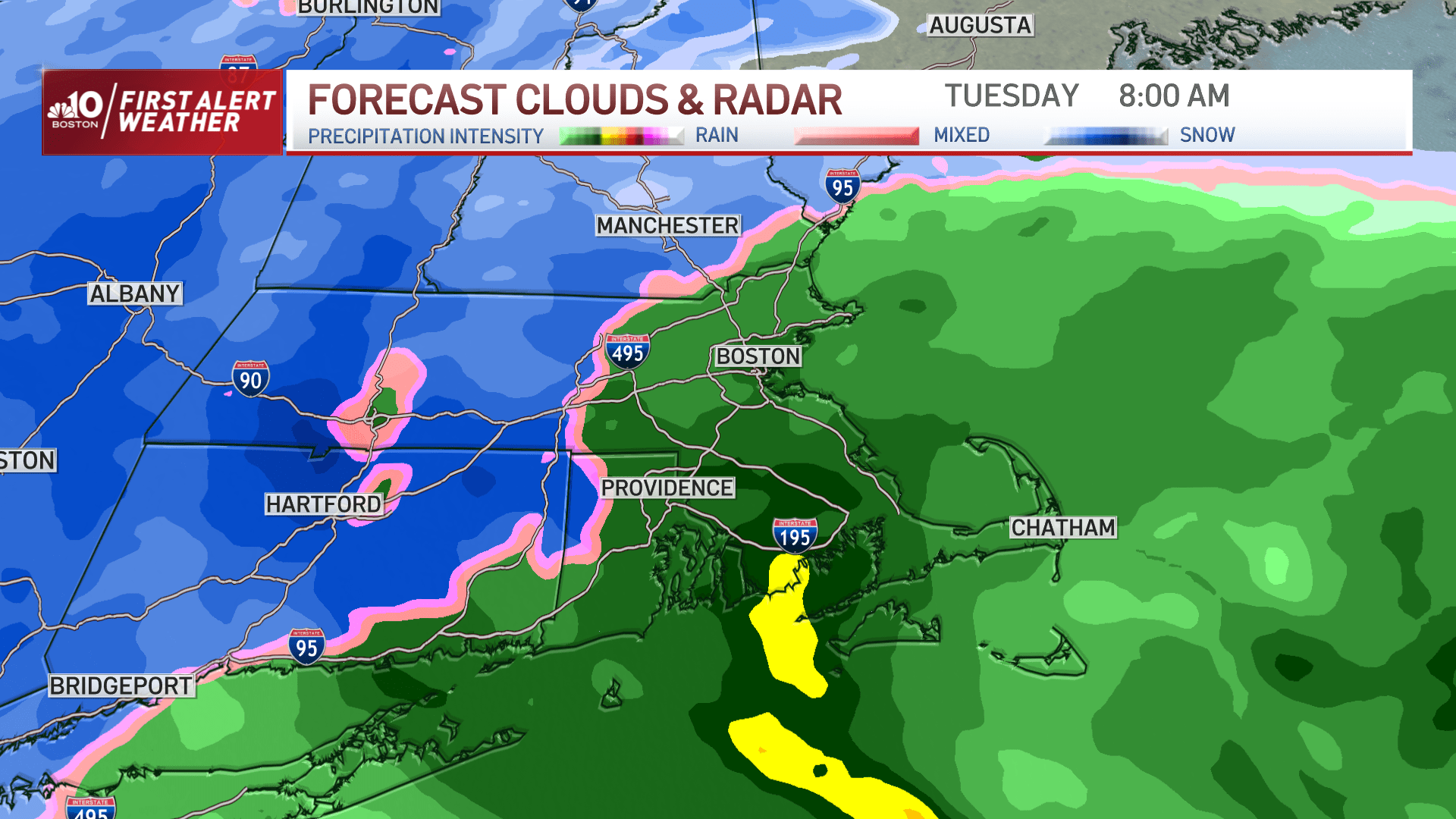
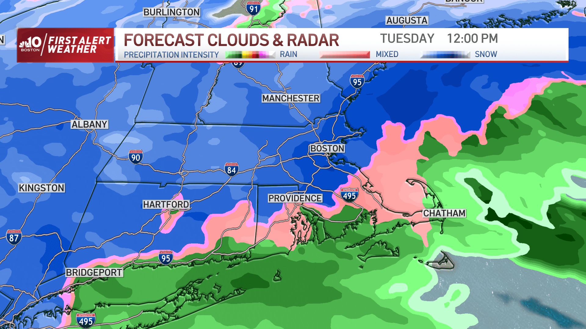
It will snow hard between 2 and 10 p.m. Tuesday in most area. Snow fall and snow coverage will gradually taper after that.
Expect some lingering pockets of snow at the coast on Wednesday.
Amounts
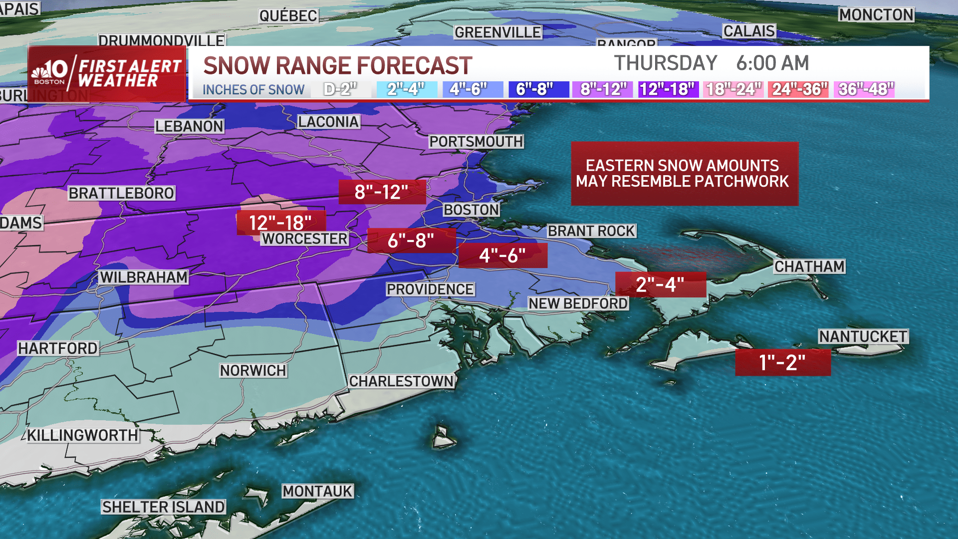
This is likely to be the biggest storm of the winter. The jackpot zone will be north and west of the city, generally outside of I-495, from central Mass. into southwest New Hampshire where 12-18 inches is expected.
Otherwise, it's 6-12 inches from I-128 to I-495 west of Boston, around 6 inches in the city itself, and lesser amounts right along the immediate coast of Cape Ann to the South Shore and to Cape Cod (2-4 inches).
Wind
The northeast wind will ramp up during the day on Tuesday, with numerous gusts 30-40 mph inland and 40-50 mph gusts at the coast. A period of 50-60 mph gusts at the coast Tuesday evening and isolated gusts to 70 mph will be possible from the tip of Cape Ann to the outer Cape.
This will result in pockets of damage and outages. The wind will shift around to the north then eventually north-northwest on the backside of the storm and remain strong Tuesday night into early Wednesday.
I do anticipate some gusts of up to 40 mph to linger through the day Wednesday. This could hamper restoration efforts for those that do lose power.
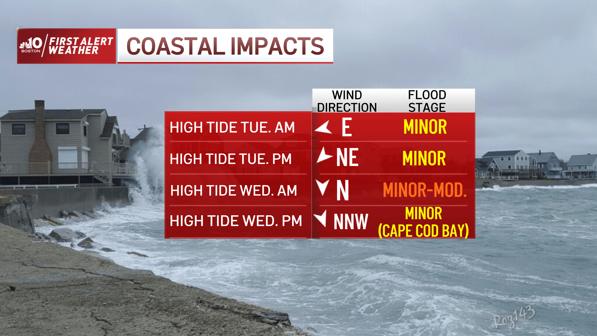
Coastal concerns
Multiple tide cycles will be impacted by coastal flooding and significant beach erosion, with 1-3 feet of inundation. This could result in some roads, low-lying areas and basements to flood.
Thankfully, tides are astronomically low. And this should limit the flood potential to minor flood stage, though a few pockets of moderate flooding are possible for the Wednesday morning tide cycle.