Support WBUR
What to know about this weekend's snowstorm
Snow is on the way to New England, and the picture is becoming clearer on the timing and impacts through Sunday.
Snow is expected to arrive 8 - 10 p.m. Saturday night from west to east, although a few pockets of light snow or snow showers may form ahead of the steadier shield of precipitation. Snow is expected to ramp up quickly, and continue to fall at a moderate-to-heavy clip through the overnight into pre-dawn Sunday. Snowfall rates of 0.5" to 1" per hour are anticipated at times during that period.
There may be a lull in the action during the morning hours where the intensity drops a bit. For the city itself, expect a brief start as wet snow before the rain/snow line comes into play, resulting in a mix with and changeover to rain. That zone will likely push inland to perhaps Rt. 128 for a short period through tomorrow morning. A change back to snow in most of eastern Mass. is expected, even at the coast as colder air wraps around the storm center. A burst of snow from midday to early afternoon — including in Boston — could push through before the back edge of the snow comes in 4 - 6 p.m. from west to east.
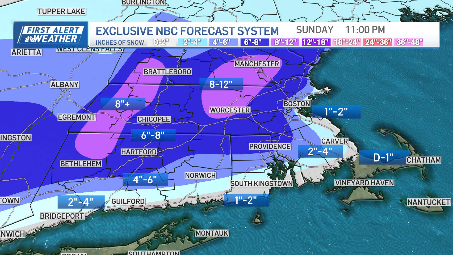
Expected snowfall:
The jackpot zone will be north and west of Boston, particularly outside of Rt. 128 where 4-8" of snow is expected. Outside of I-495 and into the Worcester Hills and southwest NH, expect some totals over 8". Closer to the coast, amounts will drop off considerably — 2-4" of snow for Metrowest and 1-3" for the city, North & South Shores with a coating possible on Cape Cod.
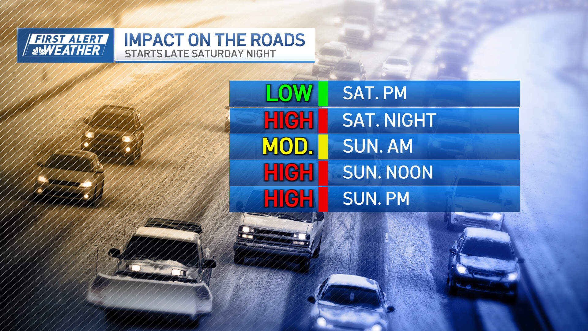
The biggest impact from all this will be hazardous travel. Road conditions will deteriorate late this evening and tonight and continue to go downhill through Sunday morning. Visibility will be reduced to 1/4 - 1/2 mile at times in the moderate to heavier bursts of snow, and slippery travel conditions will result. The snow is expected to be a wetter consistency when it first begins, but then turn fluffier inland, and therefore be easier to move around on Sunday as the temperature drops.
Gust and wind chill values:
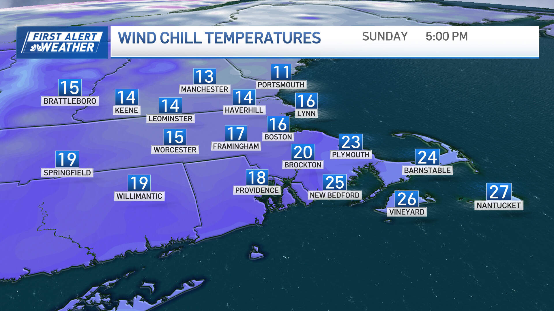
The wind isn't a big concern with this storm. Gusts to 40 mph along the immediate coast and 40-50 mph on Cape Cod may result in isolated limb damage or a few outages. Elsewhere, there will be numerous gusts 20-30 mph, and isolated gusts to 35 mph (out of the northeast, then north) Sunday morning. Wind chill values will only be in the teens for much of the day Sunday — so kids and adults alike need to be bundled up for playing and cleaning up.
A quick freeze up:
As colder air comes in behind the storm's departure, a quick drop in temperature below the freezing mark along and east of Rt. 128 and into southeast MA to Cape Cod may result in a quick freeze up of any lingering moisture on the roads.
So although the lower snow totals will be found in these areas, any untreated surfaces will become slick during the late afternoon to evening hours tomorrow.
Expect two more incoming storms:
Quiet weather is anticipated on Monday ahead of our next storm which is likely to be multifaceted. A very brief burst of snow well inland is possible Tuesday evening before quickly changing to rain. It will rain hard Tuesday night into Wednesday morning with localized flooding and 1-2" of rain (with a potential to be higher). Damaging wind gusts may come into play as well. Another storm is looking likely next weekend on Saturday - and could feature snow, ice and rain depending on track.
This article was originally published on January 05, 2024.
