Support WBUR
Light snow for some on Friday, and a bitter cold weekend ahead
Our next snow-maker won’t impact everyone in New England, but as of Thursday it's zipping east out of the northern plains, heading in our direction.
This disturbance will remain moisture-starved for most of its cross-country journey, with only a small amount of Gulf of Mexico moisture finally meeting it as it nears Pennsylvania overnight.
The storm will pick up a little bit of ocean moisture as it approaches New England, expanding its snow shield. The storm center itself will pass south of us, keeping the heaviest precipitation over the Mid-Atlantic region and ocean south of New England.
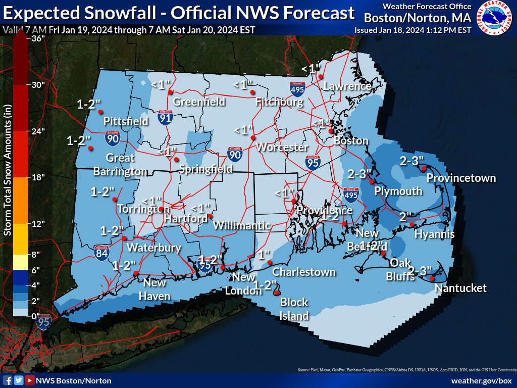
Since we'll be on the fringe of the storm, don't expect much in terms of accumulation. The snow will start as some flurries Friday morning, turn steadier and more widespread during the middle to late morning, and linger until evening, around or shortly after suppertime. When all is said and done, very little if any snow will likely have fallen in central and northern New England, but the southern half of New England should pick up amounts ranging from a coating to 2 inches, though an isolated amounts of 3 or 4 inches are possible from southern Plymouth County to around the Cape Cod Canal. This will be enough to bring out road treatments for some and plows in spots south of Boston.
Behind the storm, the coldest air of the winter so far arrives Saturday. While that may not be saying much, it’ll still have quite a wintry bite as it arrives with more clouds than sun, a steady northwest breeze and temperatures struggling to surpass 20 degrees — with wind chill values rising from subzero in the morning to single digits at the warmest time of day.
On the Outer Cape, some ocean-effect snow showers are possible Saturday afternoon as cold air moves across the relatively warm ocean waters.
By Sunday, sunshine will be abundant and temperatures should rebound into the 20s, with slightly less wind. Temperatures will continue to rebound close to New England's seasonal norm, with highs in the 30s to around 40 by Monday.
A warmer-than-normal stretch arrives for the remainder of next week, and though it likely won’t quite feel like a spring fling due to clouds and periodic showers, even temperatures in the 40s will be about 6-12 degrees above normal for the fourth week of January.
