Support WBUR
The drought in Massachusetts is getting worse
Thanks to a very dry fall, almost all of Massachusetts is now officially in a drought and many areas of the state are on high alert for wildfires.
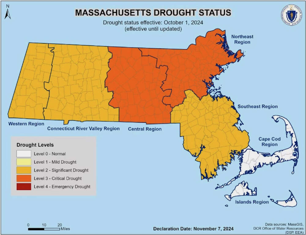
On Thursday, the state declared a “significant drought” in southeastern Massachusetts, the Connecticut River Valley and western Massachusetts. The drought designation in central and northeastern Massachusetts was elevated to “critical,” and residents are being asked to conserve water.
“This autumn has felt different for all of us,” Energy and Environmental Affairs Secretary Rebecca Tepper said in a statement. “Climate change is bringing drier weather to our state at times and extreme precipitation at others. It is critical that we all practice water conservation methods, especially indoors, and adhere to local requirements to decrease the stress on our water systems.”
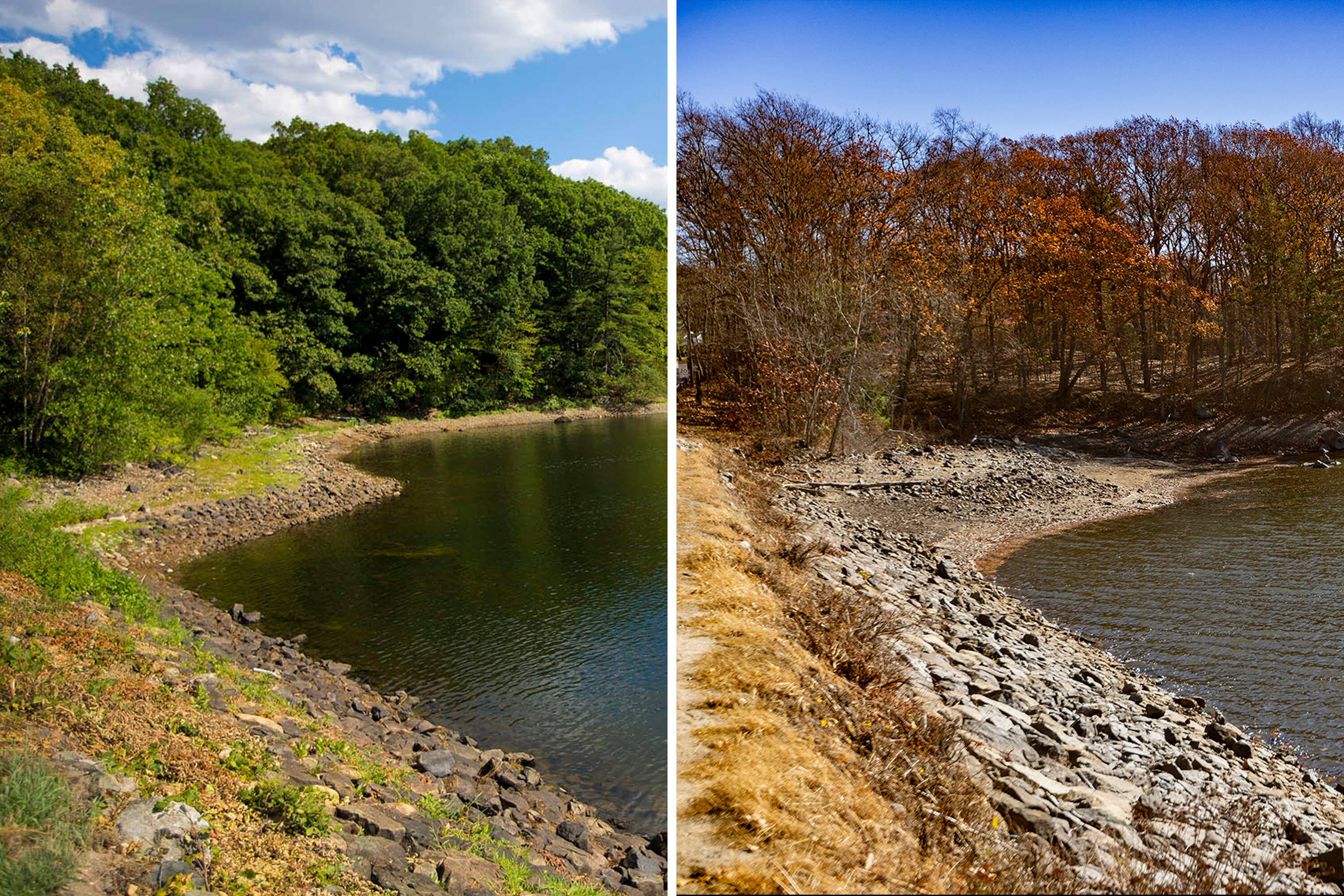
Since August, when the first signs of drought began, much of state has received 7 to 9 inches less rainfall than average. And during the month of October, which was particularly dry, some areas recorded their lowest rainfall totals ever, according to the state.
The dry conditions have fueled wildfires and created what Massachusetts Emergency Management Director Dawn Brantley called “a historical fall fire season.”
The state reported 47 active wildfires burning of Thursday; at least 854 wildfires have ignited over the last few months, burning approximately 1,365 acres and periodically creating smokey or hazy conditions.
"Given the ongoing drought conditions across Massachusetts, our wildfire risk remains high, with the dry landscape providing ample fuel for fires to spread quickly,” Dave Celino, the state’s chief fire warden, warned in a statement. “We urge everyone to exercise extreme caution and remember, even small sparks can ignite a larger fire in these conditions.”
The National Weather Service issued a “critical fire weather” or “red flag warning” for all of Massachusetts as well as northern Connecticut and Rhode Island beginning at 8 a.m. Friday. “Any fires that start may spread rapidly and become difficult to extinguish,” the service says.
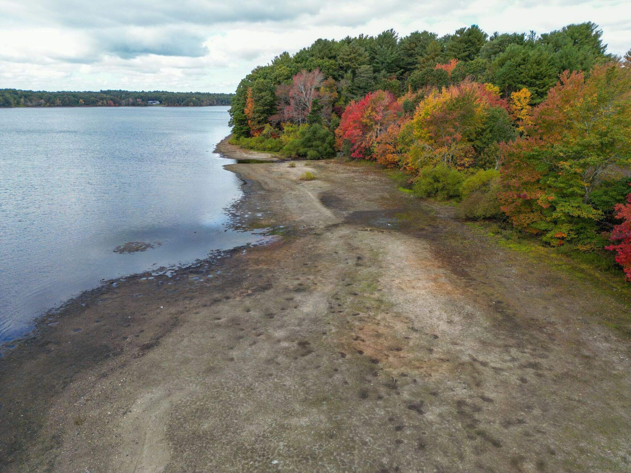
The ongoing drought is also taking a toll on the state’s rivers and streams. Water levels and flow rate has decreased, and some smaller brooks have run dry.
"Even though many think of droughts as a summer event, our rivers and streams are hurting now in November," said Katharine Lange, policy director at the Mass Rivers Alliance. "When water quantity is low, water quality also suffers. Nutrients, chemicals and debris are concentrated in a smaller amount of water, making habitat conditions even worse for aquatic life, and limiting recreational opportunities."
Lange said that sections of several streams in the state — like the First Herring Brook in Pembroke, Powisett Brook in Dover, and Bow Brook in Lancaster — have dried up. She noted that the water level in Silver Lake in Kingston, which feeds the Jones River and supplies water to Brockton, is also so low that it's no longer flowing into the river.
"This is a waterway that supports a herring run," she said. "And without a way to go downstream, the juveniles that spawned in the lake earlier this year will have no way to reach the sea."
Groundwater levels around the state are also dropping, and some local public drinking water systems are beginning to see decreasing reservoir levels, according to the state.
The Massachusetts Water Resources Authority, the largest provider of drinking water in the state, is not currently under strain.
The U.S. Drought Monitor, which uses slightly different metrics for determining drought than the state, shows all of Massachusetts and most of the Northeast U.S. in a drought.
It’s not atypical for the Northeast to experience periodic and temporary droughts, but scientists say climate change is making them more acute and possibly more frequent. Massachusetts experienced severe droughts in 2022, 2020 and 2016.
Massachusetts ranks drought severity on a scale of 0 to 4, with 0 being "normal" and 4 being an "emergency." The state is divided into seven regions, and each is assigned a level based on local rainfall data, ground water levels, stream flow and wildfire risk.
The state has issued the following water use recommendations for residents and businesses:
Level 3 – Critical Drought
- Minimize overall water use
- Follow local water use restrictions
- Fix any toilet or faucet leaks immediately
- Aggressively reduce indoor water use by taking shorter showers, running dishwashers and washing machines only on a full load
Level 2 – Significant Drought
- Minimize overall water use and be particularly mindful of indoor water use
- Follow local water use restrictions
This article was originally published on November 07, 2024.