Support WBUR
Snowstorm now to drop up to 6 inches in Boston ahead of Arctic blast
Bostonians, get ready for a wintry mix of weather as we close out the weekend.
Here’s what to expect in the city and across the region.
Sunday: How the snow will move in
The day began with areas of patchy black ice and locally dense fog in some spots. In places where temperatures hovered near freezing, untreated surfaces and elevated roadways were slippery.
Snow showers will start to spread into southern New England this afternoon, starting in western areas at between around 2 or 3 p.m. before advancing eastward.
Boston may see a brief period of rain or a rain-snow mix as precipitation begins. However, colder air set to arrive from the north will quickly flip any rain to snow between 5 and 6 p.m.
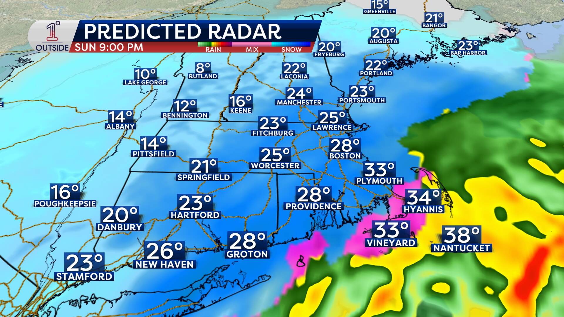
The heaviest snow is expected between 7 p.m. and midnight, with steady snow falling across much of the region.
Reduced visibility, blowing snow and tough travel conditions will be likely during this period. The snow will gradually taper in intensity after midnight, with light snow showers exiting around 4 a.m.
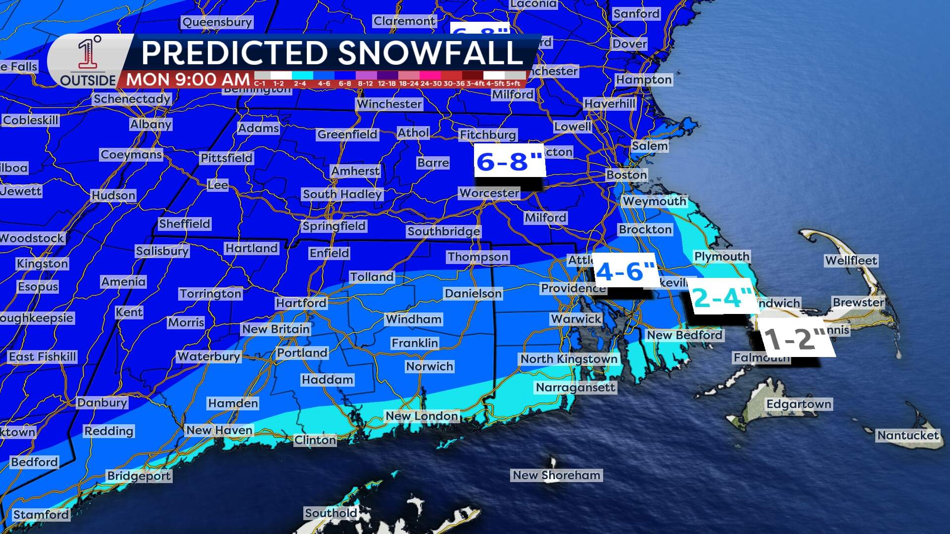
Bostonians can expect between 4 to 6 inches of snow, with higher totals of between 6 to 8 inches in areas just northwest of the city. Southeastern areas, including the South Shore and Cape Cod, will see lower totals due to a delayed arrival of colder air.
Monday: Bitter cold takes hold
The storm will taper off around dawn Monday, leaving behind widespread snow totals of between 4 to 8 inches across the region.
But the intensity of this weather pattern doesn't end there.
Arctic air will move in, dropping temperatures into the single digits and teens by sunrise.
Monday’s high temperatures will struggle to reach 20 in Boston, with wind chills making it feel closer to 10 degrees or even lower. Gusty winds of 25–35 mph will create blowing and drifting snow.
Advocates for Boston's homeless population are preparing for the drop in temperatures. Barbara Trevisan, a spokesperson for the Pine Street Inn, said outreach workers will spend more time checking on people on the streets and encourage them to come indoors to stay safe from the cold.
“They will check on people several times throughout the night, even have them come into the van and sit to warm up for a while,” Trevisan said.
Homelessness has been on the rise, and shelters are already crowded. About 600 people stay overnight at Pine Street’s shelters now, compared to roughly 500 at the same time last year, Trevisan said. She said Pine Street is setting up lobbies and other common spaces to accommodate more people.
“In some places there are chairs rather than places where people can lay down, but at least they can get in from the cold,” she said.
Advocates say if you notice someone outside who might be in distress, call 911 for help.
For those traveling or commuting, it’s important to stay ahead of the conditions. Untreated surfaces may become slick as early as late afternoon and evening Sunday, with Monday morning likely to be impacted by snowy and icy patches as the Arctic air freezes everything solid.
Tuesday: Dangerously cold wind chills
By Tuesday morning, actual low temperatures dip into the single digits for many. They'll hit the lower teens in Boston, with sub-zero readings in northern New England.
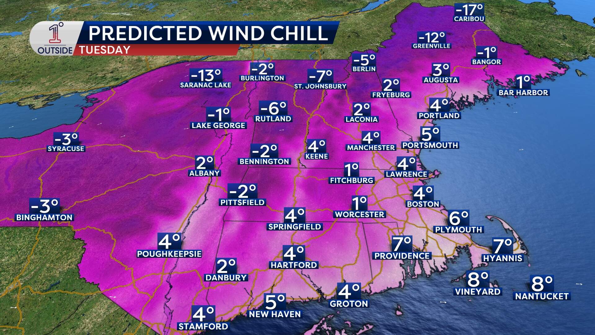
Wind chills will make it feel like 10 to 15 below zero in parts of northern New England and 0 to 10 below in southern areas, including the city.
Daytime highs on Tuesday will only reach the teens in Boston, while northern areas will remain in the single digits.
What’s next?
The Arctic blast will persist through the middle of the week, with little relief from the cold until late in the week. A few lake-effect snow showers may drift into western parts of New England on Monday and Tuesday, and a few flurries from time to time may survive the trip farther east.
With reporting from WBUR's Priyanka Dayal McCluskey.
This article was originally published on January 17, 2025.
