Support WBUR
A messy mix of rain and snow expected Friday
The weather the next few days brings a little bit of everything: snow, sleet, freezing rain and rain. What you get depends on where you are — and just as importantly, what time of day it is.
For the Boston area, the biggest takeaway is that early impacts are limited, but conditions can deteriorate quickly after dark as temperatures slip and precipitation flips back toward snow. Then, once that's over, keep an eye on lingering snow showers Saturday and a developing coastal storm likely to pass to the southeast Sunday night into Monday.
Friday's system
The atmosphere is setting the stage for mixed precipitation because of what’s happening above our heads. There’s a layer of warmer air aloft (roughly around 6,000 feet up) that pushes north during the day Friday, while colder air near the surface hangs on in parts of the region. That combination is what turns straightforward snow into sleet or freezing rain — the kind of in-between precipitation that can cause travel problems. As the wave of low pressure goes by, colder air wraps in behind it, allowing many areas to change back to snow late Friday evening and night.
Timing matters a lot here. Friday morning will be dry with a burst of snow arriving early to mid afternoon. Mixing of snow and rain becomes more common around and south of the Mass. Pike. Areas farther north and inland tend to hold onto more snow. Even so, this isn’t a deep, locked-in Arctic air mass, so during the daylight hours the warmer temperatures and stronger sun angle limit widespread snow-covered road impacts. Roads may start out wet, slushy in spots, and that's changeable.
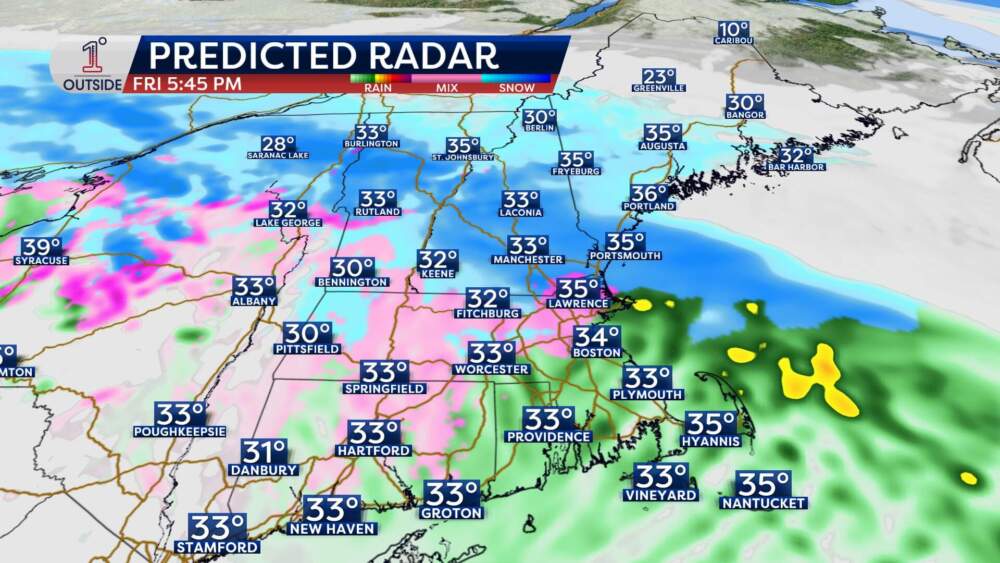
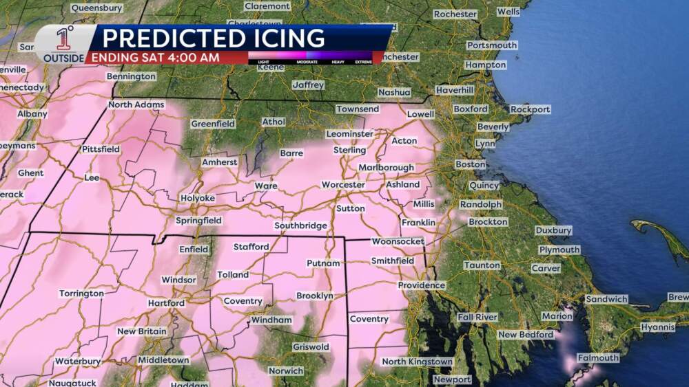
The concern rises noticeably after sunset. As temperatures gradually fall Friday evening, even a thin glaze from freezing rain or a trace of sleet can turn untreated surfaces slick in a hurry. The highest risk for that light icing looks to be outside Route 128, especially near and west of the I-495 belt into the Worcester Hills.
The good news is that the icing signal is light enough that power outages are not anticipated. The less good news is that travel can still get tricky, because it doesn’t take much ice to create problems on bridges, ramps and side roads.
Snowfall is a classic south-to-north increase with a tight gradient, which means small changes in temperature profiles or storm track can nudge the totals around. Through late Friday afternoon, most places don’t add up to much, if anything — generally a coating with an inch or so possible in central Mass.
The more meaningful accumulation comes Friday evening into the first part of the overnight as the sun sets, surfaces cool and colder air works in. In that window, the Boston-to-Worcester zone is positioned for a plowable event, while totals ramp up faster north of Boston into the Merrimack Valley and northern Essex County.
Accumulation
- Coating to about an inch is most likely near the canal and Cape Cod.
- 1 to 2 inches around Plymouth and Duxbury. Moving north into Quincy and Weymouth and near Boston, amounts trend more toward 2 to 3 inches.
- Worcester expected to see 3 to 4 inches.
- North and northwest of Worcester, including the Rt. 2 corridor, northern Berkshires, Merrimack Valley, and northern Essex County, a 4 to 6 inch range becomes more likely.
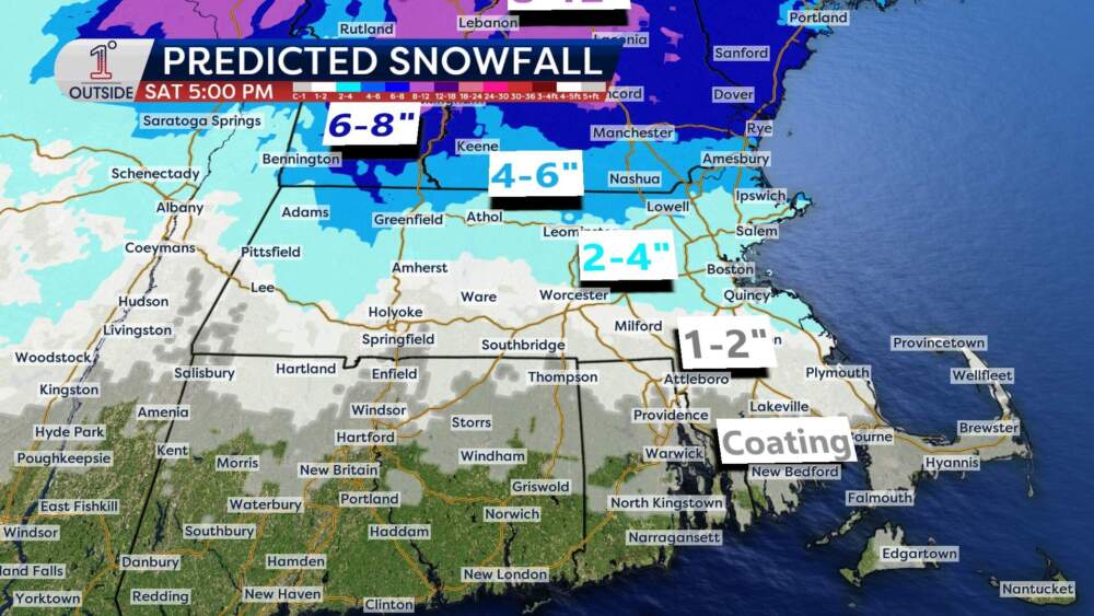
Farther north into southern New Hampshire, 6 to 8 inches is on the table, with localized higher totals possible where snow bands linger longest. If the sleet-freezing rain line presses farther north than expected, totals could come down in a hurry near the Massachusetts and New Hampshire border. If cold air holds firm, the heavier snow zone can expand a bit farther south.
Saturday's weather
By Saturday morning, the storm is pulling away and the snow becomes lighter and more scattered, but temperatures are colder, so any lingering snow showers or flurries can still create isolated slick spots. Expect brightening later Saturday, with plenty of clouds but the potential for breaks of sun as the day goes on.
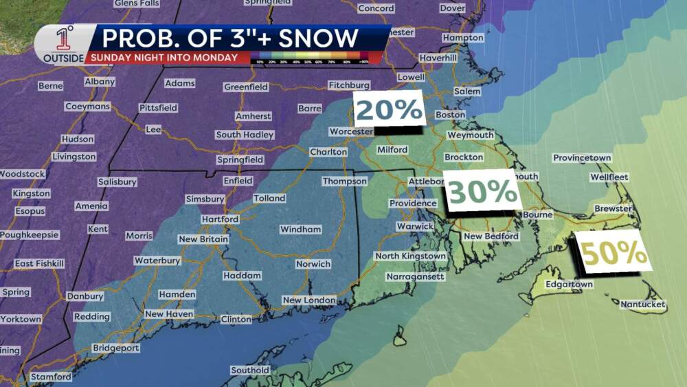
Watching Sunday's potential storm
That next feature is a coastal storm signal for Sunday night into Monday, and the honest truth right now is that track uncertainty is still too high to responsibly pin down totals. An offshore track looks most likely at the moment, but this is exactly the kind of setup where a small shift, even 20 to 50 miles, can be the difference between a glancing blow or a near miss. At this stage, the best guidance points to higher odds of at least some accumulation south of Boston toward the South Shore, Cape and Islands, with lower odds farther inland and north and west of the city. Those probabilities would climb quickly if the storm edges closer to the coastline.
Get the latest updates at 1DegreeOutside.com or on the free 1DegreeOutside mobile app.