Support WBUR
What’s The Polar Vortex? Think About Your Washing Machine
As the region's temperatures plummeted Wednesday evening behind a band of snow squalls, the air became dry and the feeling of being in the Arctic enveloped all of New England. This deep cold won't last, but is the second time this winter we've had extremely cold temperatures.
At any given time there are generally four air masses that can be found across the United States:
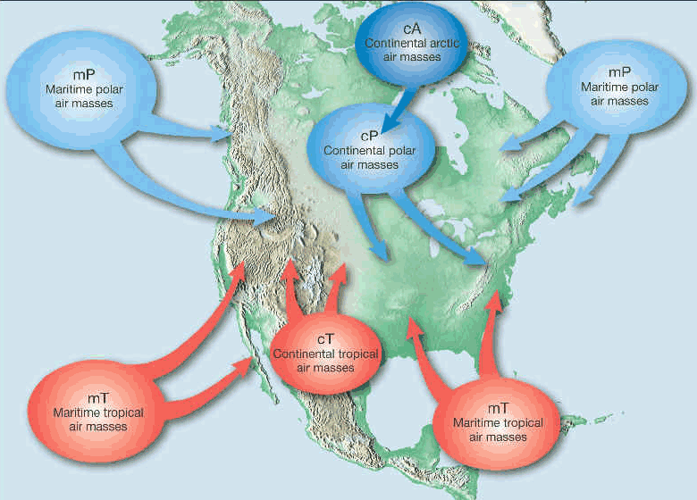
- Continental polar air, which originates in Canada, is the most common air mass we find here in New England. This is a dry, cold air mass in the winter and a pleasantly mild air mass during the warmer months.
- Maritime polar air, which is also cool but has a lot more moisture, is the type of air we find when winds turn and come from the ocean.
- The hot and humid stuff arrives from the South; we call it maritime tropical. This air mass contains a lot of warmth and a lot of moisture and even in the winter it could propel temperatures into the 60s.
- The fourth main air mass is continental tropical, which we don't see very much. This is warm and dry and would have a hard time crossing the country in order to get into New England. This is what you experience when you head to places like Phoenix and the western part of Texas.
There is a fifth — and less common — air mass. It’s called continental arctic, and it makes its presence felt within U.S. one or more times each winter. In a very mild winter, the arctic air never makes it to the East Coast, but in other years continual shots of it keep bone-chilling temperatures lasting for weeks at a time.
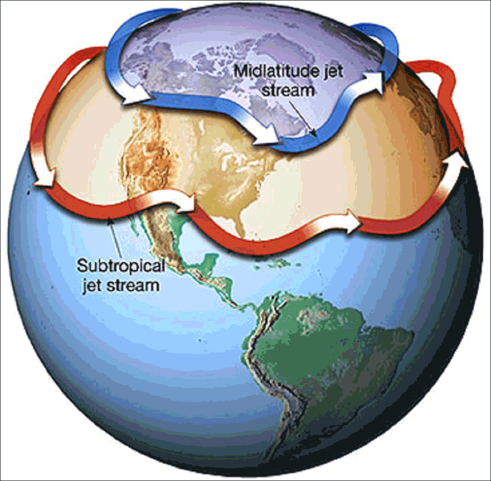
The jet stream controls the movement of these air masses and depending on its configuration, the area you live ends up warmer or colder than average. It's actually the clashing of these air masses that produces storms.
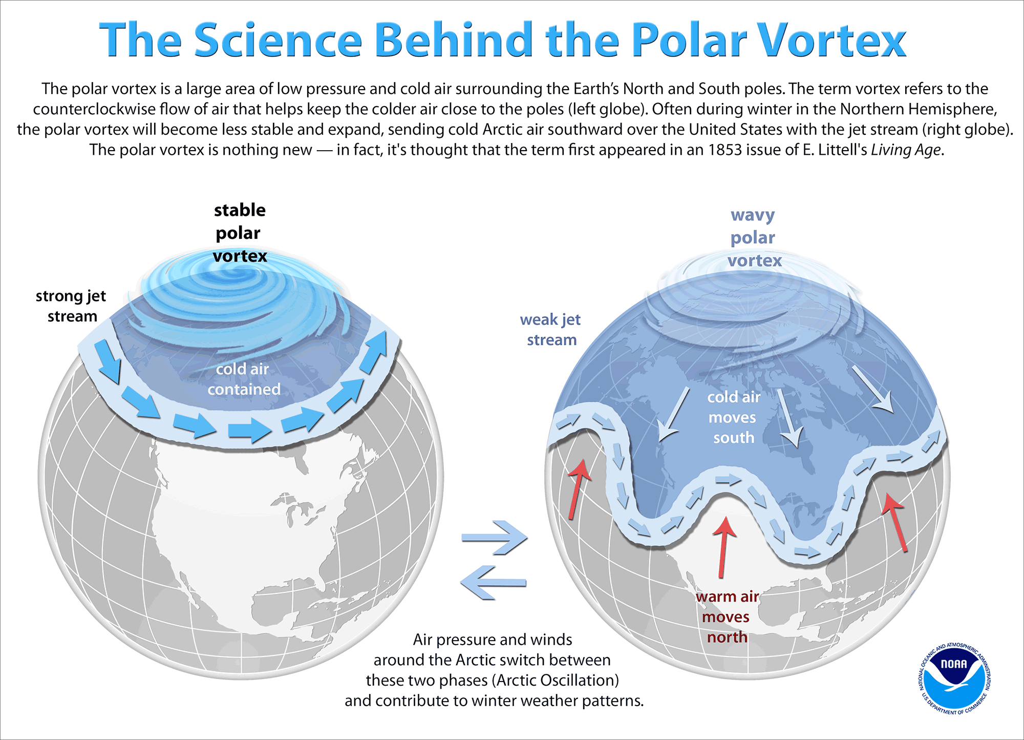
But what about the arctic air? Why does it sometimes come down across the country with such force that we have to stay inside, school is cancelled, and our machines stop working correctly? The answer lies in something called the polar vortex. This word gets thrown around an awful lot, but there's a misunderstanding about it: When it gets cold, you're not experiencing the polar vortex; you're experiencing a polar vortex that has undergone a change. The polar vortex is a fast band of winds permanently circling the top of the planet. When these winds blow really fast it keeps the cold air locked up underneath them.
The analogy I love to use is the spin cycle of a washing machine. When it's going really fast, your clothes are very tight to the drum, like the cold air tight to the top of the planet. When the winds of the polar vortex relax, much like the spin cycle stopping, the cold air flops south. In my washing machine analogy, this is when the clothes would fall into the middle. Because we're working with air, not clothes, the configuration of the flop changes. Sometimes the cold air moves south into Europe or Eurasia and other times it moves into the central or even eastern U.S. Eventually the polar vortex reestablishes itself further north and the cold air goes with it.
When there are extreme events like wind chills 50 below zero and actual temperatures not far off, some people start drawing conclusions about our changing climate, using these events as proof that it is — or isn't — happening.
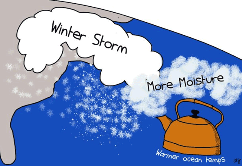
There's some research — but it's not conclusive — that says as the planet warms, those winds, which generally circulate quite rapidly at the top of the planet, will actually weaken and we will see more of these extreme cold outbreaks, in spite of the fact that overall the planet is warming. That research is not well-documented yet, but it's an area that climatologists are looking at. That's why you may hear that a warmer world actually can bring colder temperatures. (In a warmer world there's also likely more moisture, which can lead to heavier precipitation events or more extreme precipitation events.)
The atmosphere is complicated and it's these extremes that allow us to better understand it.