Support WBUR
The flakes fled south, but nor'easter brings flooding to Boston
A dramatic southerly shift in the storm track changed Boston's forecast dramatically, turning what was an expected thump of snow into a soggy Tuesday of mostly rain and some flooding. The nor-easter's low pressure center came in weaker than predicted, cutting snowfall rates.
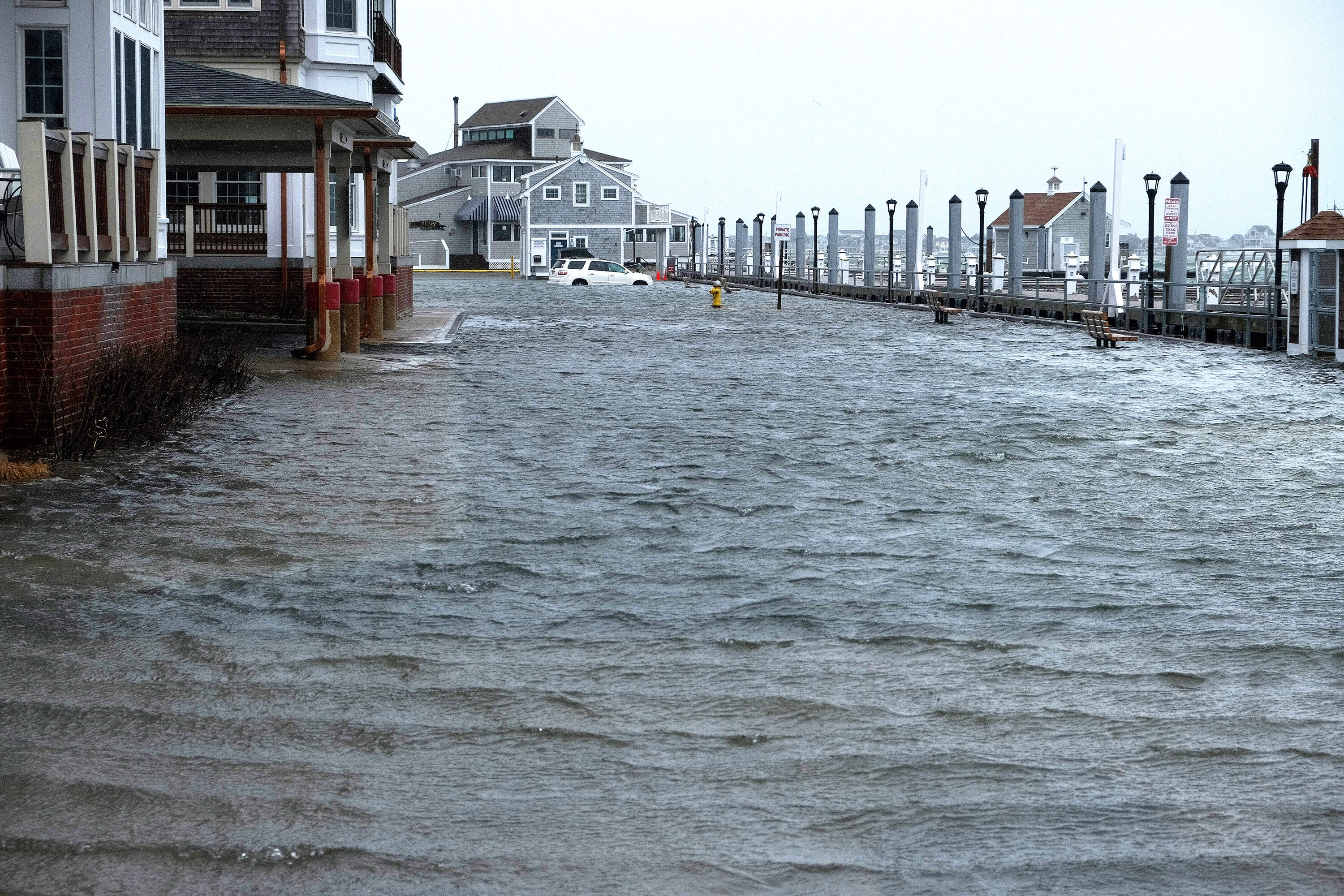
Though the snow never really materialized in Boston, the expected flooding did. In Boston, swaths of the Harborwalk in the Seaport were under water, as was Long Wharf and parts of Morrissey Boulevard. And down the coast in Scituate, a parking lot sat inundated as the high tide rolled in.
Earlier:
Snow is advancing through southern New England, on a slightly slower time frame, and will continue to fill in over the course of the morning. The steadiest period of snow will occur from 10 a.m. to 1 p.m. before the back edge arrives from west to east between 4 and 6 p.m.
This will be a low-impact event north of Boston, where only an inch or two is expected now. In the city, around 3 inches seems likely, ramping up to 4 to 6 inches on the South Shore and 6 to 8 inches on Cape Cod — the rare jackpot this time around.
There will likely continue to be surprises from this storm, with some areas ending up with closer to a foot and others barely seeing some flakes. The impact to travel and cleanup will be most difficult from late morning through the afternoon, with the worst roads conditions anticipated then.
As rain switched to a wintery mix in Boston by mid-morning Tuesday, several inches of snow had already piled up in areas across Connecticut, Rhode Island and parts of southeastern Massachusetts.
Eleven inches had fallen on West Hartford, Connecticut by 9:40 a.m., according to data posted by the National Weather Service. In Bristol, 8 inches accumulated before 9 a.m. One East Farmington resident reported over a foot under a particularly heavy band of the storm.
Holland, Massachusetts, which sits on the boarder of Connecticut, saw 4 inches build up by 8:30 a.m. North Attleborough which sits on the Rhode Island line in southeastern Massachusetts had received over 2 inches by 9:30 a.m.
In West Warwick, Rhode Island, over 4 inches piled up by 8:40 a.m. Providence, the state's capital, reported 2.3 inches at the same time.
With the back edge of the steadiest snow arriving earlier, the evening drive won't be impacted as much as previously thought, though some slippery travel is likely on untreated surfaces, with tougher travel south of Boston. Tonight as skies clear out, the temperature will drop into the 20s.
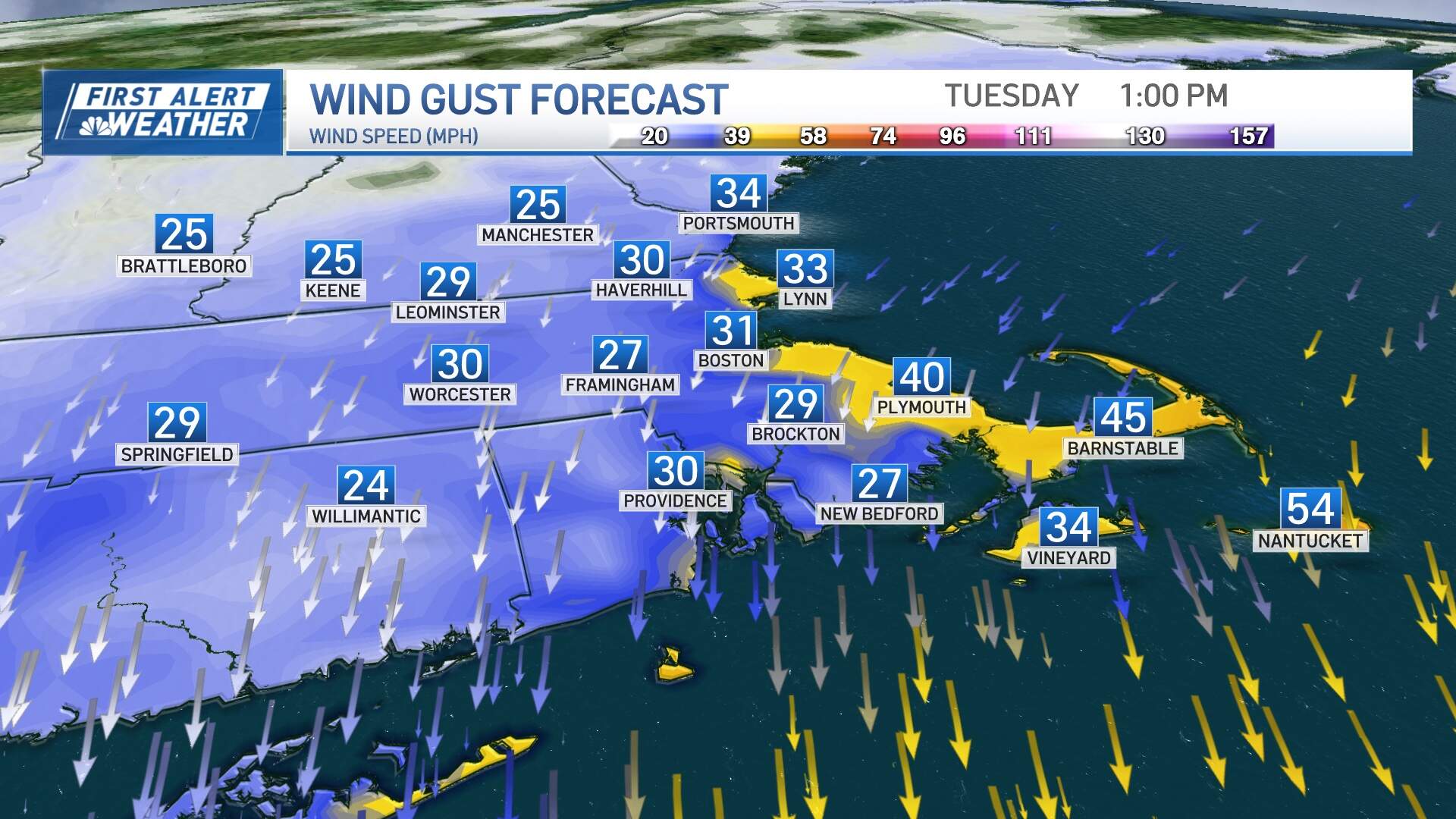
The wind won't be a concern for most, though gusts from the northeast then north will be between 20 to 30 mph inland, 30 to 40 mph at the coast and up to 55 mph on Cape Cod, where isolated pockets of damage/outages could occur.
With building seas and lingering astronomical high tides due to the recent new moon, widespread minor coastal flooding during Tuesday afternoon's high tide cycle and again Wednesday morning is anticipated. There's the chance a few locations briefly go into moderate flood stage.
The next couple of days will be brighter but cold, with a round of snow showers Thursday night that may drop a coating to a couple inches of new snow, and a chance of snow again Friday night into Saturday. Plenty to watch in the days ahead.
This article was originally published on February 13, 2024.
This segment aired on February 13, 2024.
